You are here: Home > Network List > UW - Pacific Northwest Regional Seismic Network Stations List
> Station MRBL Marblemount, WA, USA > Earthquake Result Viewer
MRBL Marblemount, WA, USA - Earthquake Result Viewer
| Earthquake location: |
Fiji Islands Region |
| Earthquake latitude/longitude: |
-19.7/-177.7 |
| Earthquake time(UTC): |
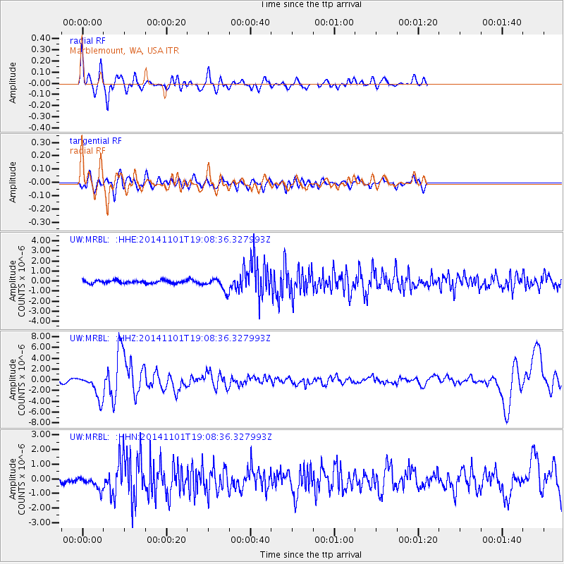
2014/11/01 (305) 18:57:22 GMT |
| Earthquake Depth: |
434 km |
| Earthquake Magnitude: |
7.1 MWW, 6.9 MI, 7.1 MWC, 7.2 MWB |
| Earthquake Catalog/Contributor: |
NEIC PDE/NEIC COMCAT |
|
| Network: |
UW Pacific Northwest Regional Seismic Network |
| Station: |
MRBL Marblemount, WA, USA |
| Lat/Lon: |
48.52 N/121.48 W |
| Elevation: |
75 m |
|
| Distance: |
84.4 deg |
| Az: |
33.742 deg |
| Baz: |
231.919 deg |
| Ray Param: |
0.044338617 |
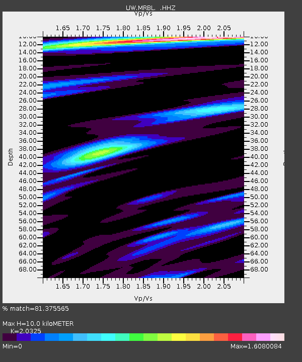
| Estimated Moho Depth: |
10.0 km |
| Estimated Crust Vp/Vs: |
2.03 |
| Assumed Crust Vp: |
6.566 km/s |
| Estimated Crust Vs: |
3.231 km/s |
| Estimated Crust Poisson's Ratio: |
0.34 |
|
| Radial Match: |
81.375565 % |
| Radial Bump: |
400 |
| Transverse Match: |
62.33964 % |
| Transverse Bump: |
400 |
| SOD ConfigId: |
813215 |
| Insert Time: |
2014-11-15 19:34:31.863 +0000 |
| GWidth: |
2.5 |
| Max Bumps: |
400 |
| Tol: |
0.001 |
|
Signal To Noise
| Channel | StoN | STA | LTA |
| UW:MRBL: :HHZ:20141101T19:08:36.327993Z | 12.17507 | 2.3562407E-6 | 1.9352994E-7 |
| UW:MRBL: :HHN:20141101T19:08:36.327993Z | 2.3664844 | 4.7448182E-7 | 2.0050072E-7 |
| UW:MRBL: :HHE:20141101T19:08:36.327993Z | 4.389482 | 6.436969E-7 | 1.466453E-7 |
| Arrivals |
| Ps | 1.6 SECOND |
| PpPs | 4.5 SECOND |
| PsPs/PpSs | 6.1 SECOND |


