You are here: Home > Network List > TD - TransAlta Monitoring Network Stations List
> Station TD004 Z > Earthquake Result Viewer
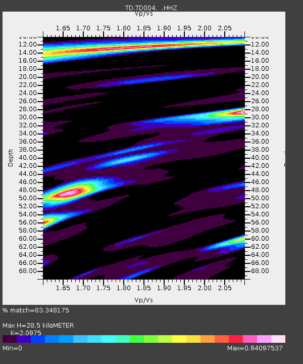
TD004 Z - Earthquake Result Viewer
| Earthquake location: |
Fiji Islands Region |
| Earthquake latitude/longitude: |
-19.7/-177.7 |
| Earthquake time(UTC): |
2014/11/01 (305) 18:57:22 GMT |
| Earthquake Depth: |
434 km |
| Earthquake Magnitude: |
7.1 MWW, 6.9 MI, 7.1 MWC, 7.2 MWB |
| Earthquake Catalog/Contributor: |
NEIC PDE/NEIC COMCAT |
|
| Network: |
TD TransAlta Monitoring Network |
| Station: |
TD004 Z |
| Lat/Lon: |
53.47 N/114.63 W |
| Elevation: |
791 m |
|
| Distance: |
90.8 deg |
| Az: |
32.223 deg |
| Baz: |
237.178 deg |
| Ray Param: |
0.041477274 |
| Estimated Moho Depth: |
28.5 km |
| Estimated Crust Vp/Vs: |
2.10 |
| Assumed Crust Vp: |
6.426 km/s |
| Estimated Crust Vs: |
3.064 km/s |
| Estimated Crust Poisson's Ratio: |
0.35 |
|
| Radial Match: |
83.348175 % |
| Radial Bump: |
376 |
| Transverse Match: |
59.930668 % |
| Transverse Bump: |
400 |
| SOD ConfigId: |
813215 |
| Insert Time: |
2014-11-15 19:37:50.114 +0000 |
| GWidth: |
2.5 |
| Max Bumps: |
400 |
| Tol: |
0.001 |
|

Signal To Noise
| Channel | StoN | STA | LTA |
| TD:TD004: :HHZ:20141101T19:09:06.48998Z | 5.19151 | 1.4662166E-6 | 2.8242587E-7 |
| TD:TD004: :HH1:20141101T19:09:06.48998Z | 1.5096185 | 6.536349E-7 | 4.329802E-7 |
| TD:TD004: :HH2:20141101T19:09:06.48998Z | 1.2695264 | 8.5505985E-7 | 6.7352664E-7 |
| Arrivals |
| Ps | 5.0 SECOND |
| PpPs | 14 SECOND |
| PsPs/PpSs | 18 SECOND |


