You are here: Home > Network List > TD - TransAlta Monitoring Network Stations List
> Station TD023 Z > Earthquake Result Viewer
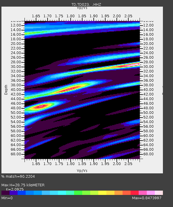
TD023 Z - Earthquake Result Viewer
| Earthquake location: |
Fiji Islands Region |
| Earthquake latitude/longitude: |
-19.7/-177.7 |
| Earthquake time(UTC): |
2014/11/01 (305) 18:57:22 GMT |
| Earthquake Depth: |
434 km |
| Earthquake Magnitude: |
7.1 MWW, 6.9 MI, 7.1 MWC, 7.2 MWB |
| Earthquake Catalog/Contributor: |
NEIC PDE/NEIC COMCAT |
|
| Network: |
TD TransAlta Monitoring Network |
| Station: |
TD023 Z |
| Lat/Lon: |
51.11 N/114.31 W |
| Elevation: |
1169 m |
|
| Distance: |
89.7 deg |
| Az: |
34.317 deg |
| Baz: |
237.423 deg |
| Ray Param: |
0.04161846 |
| Estimated Moho Depth: |
28.75 km |
| Estimated Crust Vp/Vs: |
2.09 |
| Assumed Crust Vp: |
6.178 km/s |
| Estimated Crust Vs: |
2.953 km/s |
| Estimated Crust Poisson's Ratio: |
0.35 |
|
| Radial Match: |
90.2204 % |
| Radial Bump: |
355 |
| Transverse Match: |
60.97411 % |
| Transverse Bump: |
400 |
| SOD ConfigId: |
813215 |
| Insert Time: |
2014-11-15 19:37:54.841 +0000 |
| GWidth: |
2.5 |
| Max Bumps: |
400 |
| Tol: |
0.001 |
|

Signal To Noise
| Channel | StoN | STA | LTA |
| TD:TD023: :HHZ:20141101T19:09:01.359976Z | 5.1848927 | 1.8090134E-6 | 3.4890084E-7 |
| TD:TD023: :HH1:20141101T19:09:01.359976Z | 0.9651244 | 6.2919145E-7 | 6.519278E-7 |
| TD:TD023: :HH2:20141101T19:09:01.359976Z | 1.2166924 | 7.5022643E-7 | 6.1661143E-7 |
| Arrivals |
| Ps | 5.2 SECOND |
| PpPs | 14 SECOND |
| PsPs/PpSs | 19 SECOND |


