You are here: Home > Network List > TD - TransAlta Monitoring Network Stations List
> Station TD026 Z > Earthquake Result Viewer
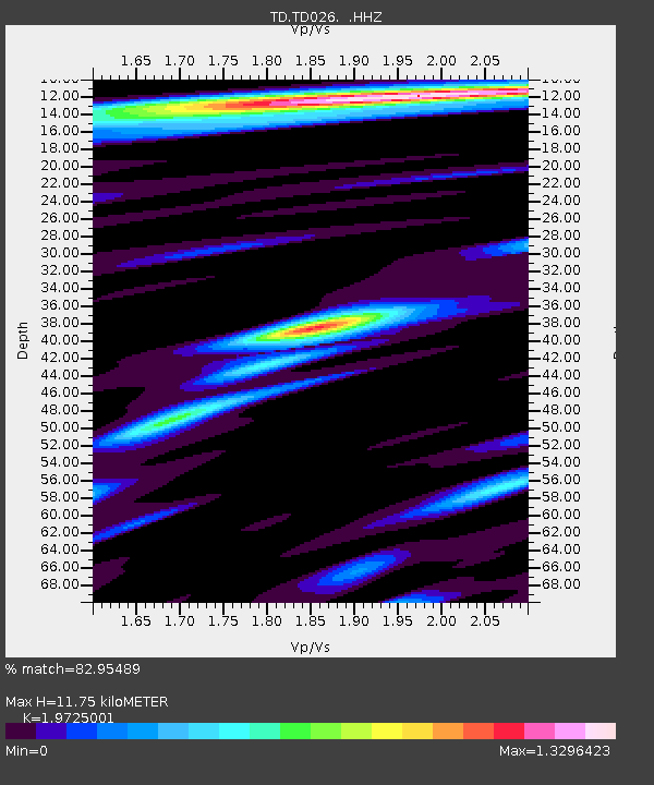
TD026 Z - Earthquake Result Viewer
| Earthquake location: |
Fiji Islands Region |
| Earthquake latitude/longitude: |
-19.7/-177.7 |
| Earthquake time(UTC): |
2014/11/01 (305) 18:57:22 GMT |
| Earthquake Depth: |
434 km |
| Earthquake Magnitude: |
7.1 MWW, 6.9 MI, 7.1 MWC, 7.2 MWB |
| Earthquake Catalog/Contributor: |
NEIC PDE/NEIC COMCAT |
|
| Network: |
TD TransAlta Monitoring Network |
| Station: |
TD026 Z |
| Lat/Lon: |
51.29 N/114.71 W |
| Elevation: |
1359 m |
|
| Distance: |
89.6 deg |
| Az: |
34.027 deg |
| Baz: |
237.109 deg |
| Ray Param: |
0.041626565 |
| Estimated Moho Depth: |
11.75 km |
| Estimated Crust Vp/Vs: |
1.97 |
| Assumed Crust Vp: |
6.178 km/s |
| Estimated Crust Vs: |
3.132 km/s |
| Estimated Crust Poisson's Ratio: |
0.33 |
|
| Radial Match: |
82.95489 % |
| Radial Bump: |
321 |
| Transverse Match: |
49.244495 % |
| Transverse Bump: |
400 |
| SOD ConfigId: |
813215 |
| Insert Time: |
2014-11-15 19:37:58.091 +0000 |
| GWidth: |
2.5 |
| Max Bumps: |
400 |
| Tol: |
0.001 |
|

Signal To Noise
| Channel | StoN | STA | LTA |
| TD:TD026: :HHZ:20141101T19:09:00.840017Z | 4.321232 | 1.4885745E-6 | 3.444792E-7 |
| TD:TD026: :HH1:20141101T19:09:00.840017Z | 1.2009574 | 2.6523546E-7 | 2.2085332E-7 |
| TD:TD026: :HH2:20141101T19:09:00.840017Z | 2.332051 | 4.993238E-7 | 2.1411357E-7 |
| Arrivals |
| Ps | 1.9 SECOND |
| PpPs | 5.6 SECOND |
| PsPs/PpSs | 7.4 SECOND |


