You are here: Home > Network List > TA - USArray Transportable Network (new EarthScope stations) Stations List
> Station R56A Bull Pasture Mountain, McDowell, VA, USA > Earthquake Result Viewer
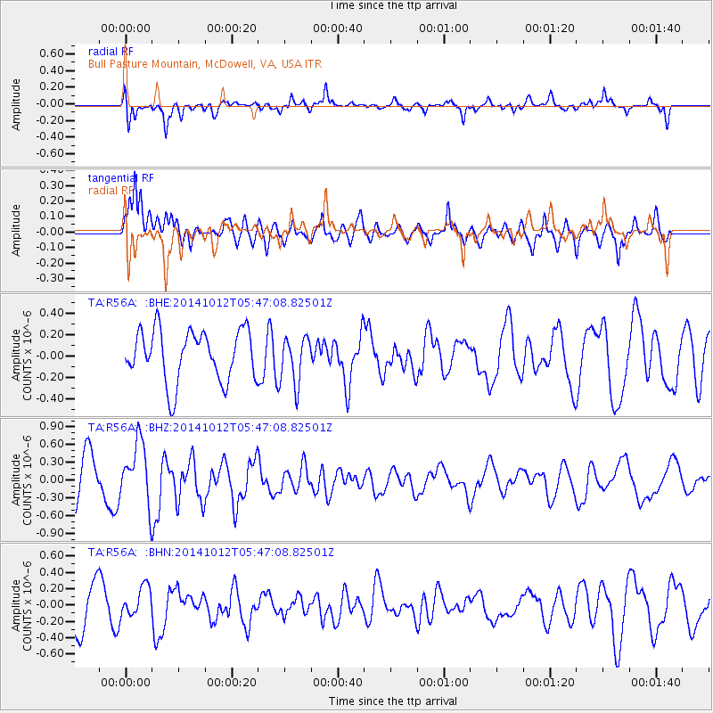
R56A Bull Pasture Mountain, McDowell, VA, USA - Earthquake Result Viewer
*The percent match for this event was below the threshold and hence no stack was calculated.
| Earthquake location: |
Reykjanes Ridge |
| Earthquake latitude/longitude: |
57.3/-33.3 |
| Earthquake time(UTC): |
2014/10/12 (285) 05:40:43 GMT |
| Earthquake Depth: |
10 km |
| Earthquake Magnitude: |
5.6 MWW, 5.5 MWC |
| Earthquake Catalog/Contributor: |
NEIC PDE/NEIC COMCAT |
|
| Network: |
TA USArray Transportable Network (new EarthScope stations) |
| Station: |
R56A Bull Pasture Mountain, McDowell, VA, USA |
| Lat/Lon: |
38.41 N/79.40 W |
| Elevation: |
902 m |
|
| Distance: |
35.4 deg |
| Az: |
257.923 deg |
| Baz: |
42.521 deg |
| Ray Param: |
$rayparam |
*The percent match for this event was below the threshold and hence was not used in the summary stack. |
|
| Radial Match: |
68.28471 % |
| Radial Bump: |
400 |
| Transverse Match: |
62.196114 % |
| Transverse Bump: |
400 |
| SOD ConfigId: |
815311 |
| Insert Time: |
2014-11-19 10:52:19.583 +0000 |
| GWidth: |
2.5 |
| Max Bumps: |
400 |
| Tol: |
0.001 |
|
Signal To Noise
| Channel | StoN | STA | LTA |
| TA:R56A: :BHZ:20141012T05:47:08.82501Z | 1.7103426 | 5.224714E-7 | 3.054776E-7 |
| TA:R56A: :BHN:20141012T05:47:08.82501Z | 0.8559453 | 1.8374976E-7 | 2.1467467E-7 |
| TA:R56A: :BHE:20141012T05:47:08.82501Z | 0.9136074 | 2.1880903E-7 | 2.3950005E-7 |
| Arrivals |
| Ps | |
| PpPs | |
| PsPs/PpSs | |


