You are here: Home > Network List > YN10 - San Jacinto Fault Zone Stations List
> Station GVAR1 GVAR1, Anza, CA, USA > Earthquake Result Viewer
GVAR1 GVAR1, Anza, CA, USA - Earthquake Result Viewer
| Earthquake location: |
New Britain Region, P.N.G. |
| Earthquake latitude/longitude: |
-5.9/151.7 |
| Earthquake time(UTC): |
2015/05/09 (129) 12:47:14 GMT |
| Earthquake Depth: |
41 km |
| Earthquake Magnitude: |
4.7 mb |
| Earthquake Catalog/Contributor: |
ISC/ISC |
|
| Network: |
YN San Jacinto Fault Zone |
| Station: |
GVAR1 GVAR1, Anza, CA, USA |
| Lat/Lon: |
33.67 N/116.71 W |
| Elevation: |
1328 m |
|
| Distance: |
94.6 deg |
| Az: |
56.753 deg |
| Baz: |
266.019 deg |
| Ray Param: |
0.040992312 |
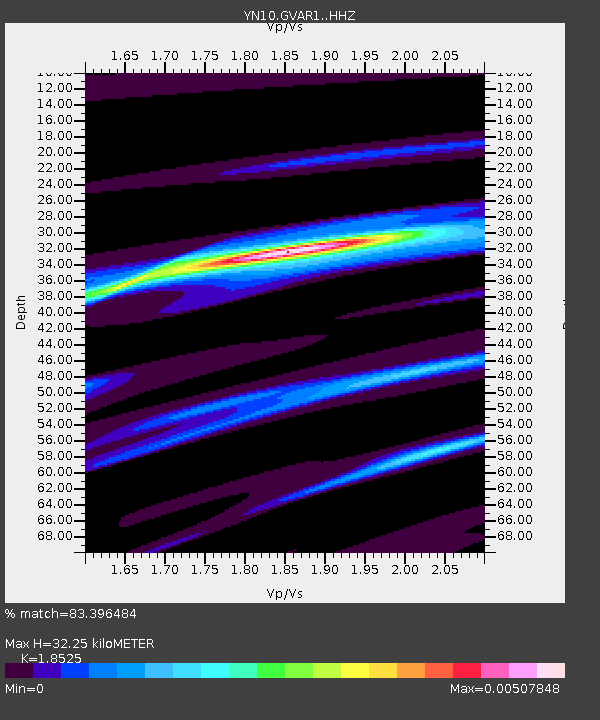
| Estimated Moho Depth: |
32.25 km |
| Estimated Crust Vp/Vs: |
1.85 |
| Assumed Crust Vp: |
6.264 km/s |
| Estimated Crust Vs: |
3.381 km/s |
| Estimated Crust Poisson's Ratio: |
0.29 |
|
| Radial Match: |
83.396484 % |
| Radial Bump: |
400 |
| Transverse Match: |
60.37277 % |
| Transverse Bump: |
400 |
| SOD ConfigId: |
7422571 |
| Insert Time: |
2019-04-18 18:44:35.826 +0000 |
| GWidth: |
2.5 |
| Max Bumps: |
400 |
| Tol: |
0.001 |
|

Signal To Noise
| Channel | StoN | STA | LTA |
| YN:GVAR1: :HHZ:20150509T12:59:59.524021Z | 0.74286896 | 1.1096741E-4 | 1.4937682E-4 |
| YN:GVAR1: :HHN:20150509T12:59:59.524021Z | 1.6414382 | 4.4475044E-7 | 2.709517E-7 |
| YN:GVAR1: :HHE:20150509T12:59:59.524021Z | 0.42107216 | 1.9584297E-7 | 4.651055E-7 |
| Arrivals |
| Ps | 4.5 SECOND |
| PpPs | 14 SECOND |
| PsPs/PpSs | 19 SECOND |


