You are here: Home > Network List > IU - Global Seismograph Network (GSN - IRIS/USGS) Stations List
> Station PMG Port Moresby, New Guinea > Earthquake Result Viewer
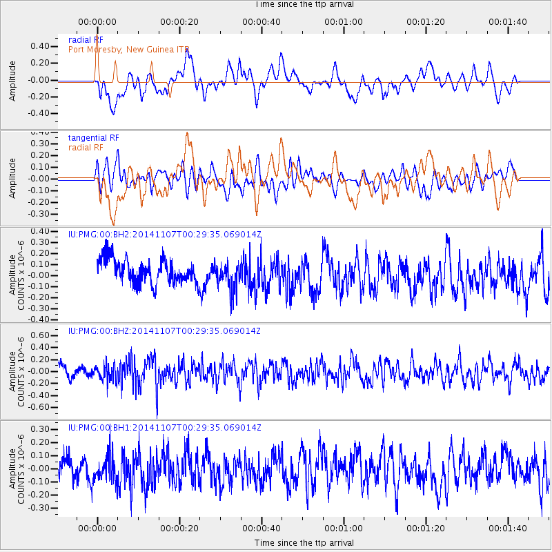
PMG Port Moresby, New Guinea - Earthquake Result Viewer
*The percent match for this event was below the threshold and hence no stack was calculated.
| Earthquake location: |
Northern Sumatra, Indonesia |
| Earthquake latitude/longitude: |
4.8/95.1 |
| Earthquake time(UTC): |
2014/11/07 (311) 00:20:47 GMT |
| Earthquake Depth: |
39 km |
| Earthquake Magnitude: |
5.7 MB, 5.4 MWB |
| Earthquake Catalog/Contributor: |
NEIC PDE/NEIC COMCAT |
|
| Network: |
IU Global Seismograph Network (GSN - IRIS/USGS) |
| Station: |
PMG Port Moresby, New Guinea |
| Lat/Lon: |
9.40 S/147.16 E |
| Elevation: |
90 m |
|
| Distance: |
53.8 deg |
| Az: |
105.247 deg |
| Baz: |
282.991 deg |
| Ray Param: |
$rayparam |
*The percent match for this event was below the threshold and hence was not used in the summary stack. |
|
| Radial Match: |
55.469593 % |
| Radial Bump: |
400 |
| Transverse Match: |
51.64871 % |
| Transverse Bump: |
400 |
| SOD ConfigId: |
815426 |
| Insert Time: |
2014-11-21 00:36:21.920 +0000 |
| GWidth: |
2.5 |
| Max Bumps: |
400 |
| Tol: |
0.001 |
|
Signal To Noise
| Channel | StoN | STA | LTA |
| IU:PMG:00:BHZ:20141107T00:29:35.069014Z | 1.4081012 | 1.2938571E-7 | 9.188666E-8 |
| IU:PMG:00:BH1:20141107T00:29:35.069014Z | 1.2230023 | 9.9339765E-8 | 8.122615E-8 |
| IU:PMG:00:BH2:20141107T00:29:35.069014Z | 1.2452259 | 1.3533433E-7 | 1.0868256E-7 |
| Arrivals |
| Ps | |
| PpPs | |
| PsPs/PpSs | |


