You are here: Home > Network List > TA - USArray Transportable Network (new EarthScope stations) Stations List
> Station A21K Barrow, AK, USA > Earthquake Result Viewer
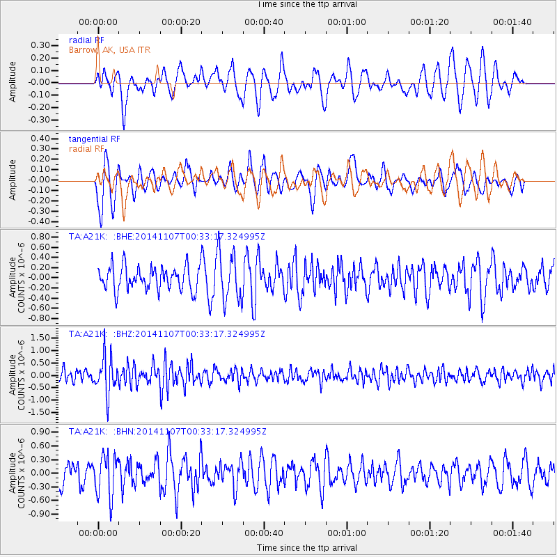
A21K Barrow, AK, USA - Earthquake Result Viewer
*The percent match for this event was below the threshold and hence no stack was calculated.
| Earthquake location: |
Northern Sumatra, Indonesia |
| Earthquake latitude/longitude: |
4.8/95.1 |
| Earthquake time(UTC): |
2014/11/07 (311) 00:20:47 GMT |
| Earthquake Depth: |
39 km |
| Earthquake Magnitude: |
5.7 MB, 5.4 MWB |
| Earthquake Catalog/Contributor: |
NEIC PDE/NEIC COMCAT |
|
| Network: |
TA USArray Transportable Network (new EarthScope stations) |
| Station: |
A21K Barrow, AK, USA |
| Lat/Lon: |
71.32 N/156.62 W |
| Elevation: |
577 m |
|
| Distance: |
91.3 deg |
| Az: |
17.819 deg |
| Baz: |
288.819 deg |
| Ray Param: |
$rayparam |
*The percent match for this event was below the threshold and hence was not used in the summary stack. |
|
| Radial Match: |
43.29737 % |
| Radial Bump: |
400 |
| Transverse Match: |
54.4873 % |
| Transverse Bump: |
400 |
| SOD ConfigId: |
815426 |
| Insert Time: |
2014-11-21 00:39:53.690 +0000 |
| GWidth: |
2.5 |
| Max Bumps: |
400 |
| Tol: |
0.001 |
|
Signal To Noise
| Channel | StoN | STA | LTA |
| TA:A21K: :BHZ:20141107T00:33:17.324995Z | 3.3543713 | 7.588311E-7 | 2.2622156E-7 |
| TA:A21K: :BHN:20141107T00:33:17.324995Z | 1.8439322 | 4.6618558E-7 | 2.5282145E-7 |
| TA:A21K: :BHE:20141107T00:33:17.324995Z | 2.0414784 | 4.7080263E-7 | 2.3061848E-7 |
| Arrivals |
| Ps | |
| PpPs | |
| PsPs/PpSs | |


