You are here: Home > Network List > TA - USArray Transportable Network (new EarthScope stations) Stations List
> Station X43A Marvell, AR, USA > Earthquake Result Viewer
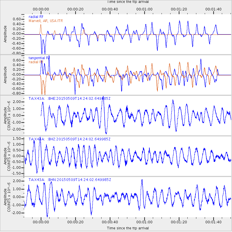
X43A Marvell, AR, USA - Earthquake Result Viewer
*The percent match for this event was below the threshold and hence no stack was calculated.
| Earthquake location: |
Kuril Islands |
| Earthquake latitude/longitude: |
46.4/153.0 |
| Earthquake time(UTC): |
2015/05/09 (129) 14:12:35 GMT |
| Earthquake Depth: |
150 km |
| Earthquake Magnitude: |
3.1 mb |
| Earthquake Catalog/Contributor: |
ISC/ISC |
|
| Network: |
TA USArray Transportable Network (new EarthScope stations) |
| Station: |
X43A Marvell, AR, USA |
| Lat/Lon: |
34.52 N/90.88 W |
| Elevation: |
53 m |
|
| Distance: |
81.1 deg |
| Az: |
48.621 deg |
| Baz: |
320.991 deg |
| Ray Param: |
$rayparam |
*The percent match for this event was below the threshold and hence was not used in the summary stack. |
|
| Radial Match: |
64.71226 % |
| Radial Bump: |
400 |
| Transverse Match: |
65.65663 % |
| Transverse Bump: |
400 |
| SOD ConfigId: |
7422571 |
| Insert Time: |
2019-04-18 18:51:02.061 +0000 |
| GWidth: |
2.5 |
| Max Bumps: |
400 |
| Tol: |
0.001 |
|
Signal To Noise
| Channel | StoN | STA | LTA |
| TA:X43A: :BHZ:20150509T14:24:02.649985Z | 1.9397697 | 8.272623E-7 | 4.264745E-7 |
| TA:X43A: :BHN:20150509T14:24:02.649985Z | 2.0028124 | 1.2017864E-6 | 6.000494E-7 |
| TA:X43A: :BHE:20150509T14:24:02.649985Z | 0.97605515 | 9.1217214E-7 | 9.345498E-7 |
| Arrivals |
| Ps | |
| PpPs | |
| PsPs/PpSs | |


