You are here: Home > Network List > US - United States National Seismic Network Stations List
> Station EGMT Eagleton, Montana, USA > Earthquake Result Viewer
EGMT Eagleton, Montana, USA - Earthquake Result Viewer
*The percent match for this event was below the threshold and hence no stack was calculated.
| Earthquake location: |
Kuril Islands |
| Earthquake latitude/longitude: |
46.4/153.0 |
| Earthquake time(UTC): |
2015/05/09 (129) 14:12:35 GMT |
| Earthquake Depth: |
150 km |
| Earthquake Magnitude: |
3.1 mb |
| Earthquake Catalog/Contributor: |
ISC/ISC |
|
| Network: |
US United States National Seismic Network |
| Station: |
EGMT Eagleton, Montana, USA |
| Lat/Lon: |
48.02 N/109.75 W |
| Elevation: |
1055 m |
|
| Distance: |
61.6 deg |
| Az: |
49.211 deg |
| Baz: |
308.629 deg |
| Ray Param: |
$rayparam |
*The percent match for this event was below the threshold and hence was not used in the summary stack. |
|
| Radial Match: |
71.045586 % |
| Radial Bump: |
372 |
| Transverse Match: |
59.008022 % |
| Transverse Bump: |
387 |
| SOD ConfigId: |
7422571 |
| Insert Time: |
2019-04-18 18:51:26.961 +0000 |
| GWidth: |
2.5 |
| Max Bumps: |
400 |
| Tol: |
0.001 |
|
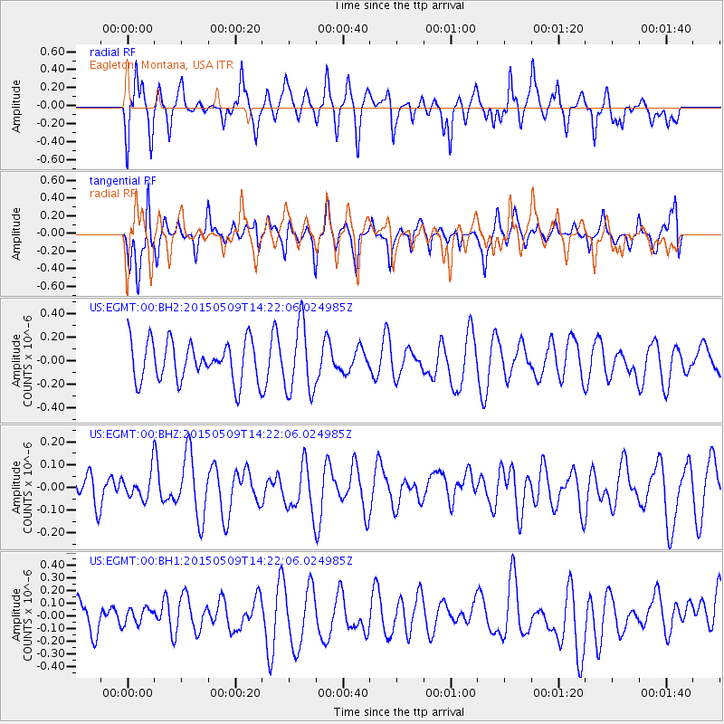
Signal To Noise
| Channel | StoN | STA | LTA |
| US:EGMT:00:BHZ:20150509T14:22:06.024985Z | 0.7300491 | 6.0437806E-8 | 8.2785945E-8 |
| US:EGMT:00:BH1:20150509T14:22:06.024985Z | 0.3698454 | 6.0317426E-8 | 1.6308822E-7 |
| US:EGMT:00:BH2:20150509T14:22:06.024985Z | 1.7343392 | 2.94954E-7 | 1.7006707E-7 |
| Arrivals |
| Ps | |
| PpPs | |
| PsPs/PpSs | |


