You are here: Home > Network List > AU - Australian Seismological Centre Stations List
> Station XMI Christmas Island Airport > Earthquake Result Viewer
XMI Christmas Island Airport - Earthquake Result Viewer
| Earthquake location: |
New Britain Region, P.N.G. |
| Earthquake latitude/longitude: |
-6.0/148.2 |
| Earthquake time(UTC): |
2014/11/07 (311) 03:33:54 GMT |
| Earthquake Depth: |
43 km |
| Earthquake Magnitude: |
6.6 MWW, 6.6 MWB, 6.9 MI |
| Earthquake Catalog/Contributor: |
NEIC PDE/NEIC COMCAT |
|
| Network: |
AU Australian Seismological Centre |
| Station: |
XMI Christmas Island Airport |
| Lat/Lon: |
10.45 S/105.69 E |
| Elevation: |
252 m |
|
| Distance: |
42.3 deg |
| Az: |
261.161 deg |
| Baz: |
87.513 deg |
| Ray Param: |
0.07316586 |
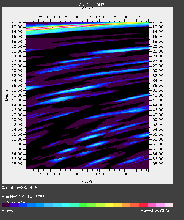
| Estimated Moho Depth: |
12.0 km |
| Estimated Crust Vp/Vs: |
1.71 |
| Assumed Crust Vp: |
4.157 km/s |
| Estimated Crust Vs: |
2.434 km/s |
| Estimated Crust Poisson's Ratio: |
0.24 |
|
| Radial Match: |
88.4459 % |
| Radial Bump: |
400 |
| Transverse Match: |
74.14427 % |
| Transverse Bump: |
400 |
| SOD ConfigId: |
815426 |
| Insert Time: |
2014-11-21 03:43:57.560 +0000 |
| GWidth: |
2.5 |
| Max Bumps: |
400 |
| Tol: |
0.001 |
|

Signal To Noise
| Channel | StoN | STA | LTA |
| AU:XMI: :BHZ:20141107T03:41:13.493993Z | 16.308979 | 1.3748812E-5 | 8.4302104E-7 |
| AU:XMI: :BHN:20141107T03:41:13.493993Z | 3.167529 | 2.2671213E-6 | 7.157381E-7 |
| AU:XMI: :BHE:20141107T03:41:13.493993Z | 4.2641826 | 3.888295E-6 | 9.1185007E-7 |
| Arrivals |
| Ps | 2.1 SECOND |
| PpPs | 7.6 SECOND |
| PsPs/PpSs | 9.7 SECOND |


