You are here: Home > Network List > II - Global Seismograph Network (GSN - IRIS/IDA) Stations List
> Station NIL Nilore, Pakistan > Earthquake Result Viewer
NIL Nilore, Pakistan - Earthquake Result Viewer
| Earthquake location: |
New Britain Region, P.N.G. |
| Earthquake latitude/longitude: |
-6.0/148.2 |
| Earthquake time(UTC): |
2014/11/07 (311) 03:33:54 GMT |
| Earthquake Depth: |
43 km |
| Earthquake Magnitude: |
6.6 MWW, 6.6 MWB, 6.9 MI |
| Earthquake Catalog/Contributor: |
NEIC PDE/NEIC COMCAT |
|
| Network: |
II Global Seismograph Network (GSN - IRIS/IDA) |
| Station: |
NIL Nilore, Pakistan |
| Lat/Lon: |
33.65 N/73.27 E |
| Elevation: |
629 m |
|
| Distance: |
80.9 deg |
| Az: |
305.341 deg |
| Baz: |
103.455 deg |
| Ray Param: |
0.047880016 |
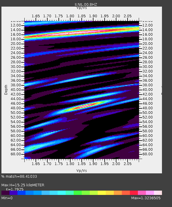
| Estimated Moho Depth: |
15.25 km |
| Estimated Crust Vp/Vs: |
1.79 |
| Assumed Crust Vp: |
6.242 km/s |
| Estimated Crust Vs: |
3.482 km/s |
| Estimated Crust Poisson's Ratio: |
0.27 |
|
| Radial Match: |
88.41033 % |
| Radial Bump: |
400 |
| Transverse Match: |
80.460075 % |
| Transverse Bump: |
400 |
| SOD ConfigId: |
815426 |
| Insert Time: |
2014-11-21 03:50:18.023 +0000 |
| GWidth: |
2.5 |
| Max Bumps: |
400 |
| Tol: |
0.001 |
|

Signal To Noise
| Channel | StoN | STA | LTA |
| II:NIL:00:BHZ:20141107T03:45:33.318975Z | 25.748934 | 1.9110557E-6 | 7.421883E-8 |
| II:NIL:00:BH1:20141107T03:45:33.318975Z | 2.3258095 | 2.3551914E-7 | 1.012633E-7 |
| II:NIL:00:BH2:20141107T03:45:33.318975Z | 4.7834935 | 4.9617546E-7 | 1.0372659E-7 |
| Arrivals |
| Ps | 2.0 SECOND |
| PpPs | 6.6 SECOND |
| PsPs/PpSs | 8.6 SECOND |


