You are here: Home > Network List > IU - Global Seismograph Network (GSN - IRIS/USGS) Stations List
> Station ULN Ulaanbaatar, Mongolia > Earthquake Result Viewer
ULN Ulaanbaatar, Mongolia - Earthquake Result Viewer
| Earthquake location: |
New Britain Region, P.N.G. |
| Earthquake latitude/longitude: |
-6.0/148.2 |
| Earthquake time(UTC): |
2014/11/07 (311) 03:33:54 GMT |
| Earthquake Depth: |
43 km |
| Earthquake Magnitude: |
6.6 MWW, 6.6 MWB, 6.9 MI |
| Earthquake Catalog/Contributor: |
NEIC PDE/NEIC COMCAT |
|
| Network: |
IU Global Seismograph Network (GSN - IRIS/USGS) |
| Station: |
ULN Ulaanbaatar, Mongolia |
| Lat/Lon: |
47.87 N/107.05 E |
| Elevation: |
1610 m |
|
| Distance: |
64.7 deg |
| Az: |
330.657 deg |
| Baz: |
133.634 deg |
| Ray Param: |
0.05865129 |
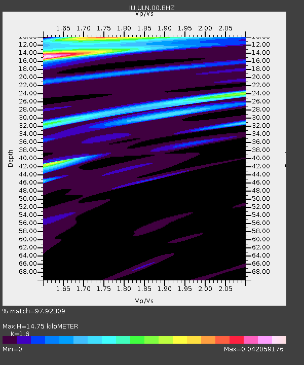
| Estimated Moho Depth: |
14.75 km |
| Estimated Crust Vp/Vs: |
1.60 |
| Assumed Crust Vp: |
6.642 km/s |
| Estimated Crust Vs: |
4.151 km/s |
| Estimated Crust Poisson's Ratio: |
0.18 |
|
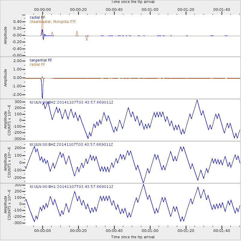
| Radial Match: |
97.92309 % |
| Radial Bump: |
400 |
| Transverse Match: |
99.97417 % |
| Transverse Bump: |
6 |
| SOD ConfigId: |
815426 |
| Insert Time: |
2014-11-21 03:51:09.488 +0000 |
| GWidth: |
2.5 |
| Max Bumps: |
400 |
| Tol: |
0.001 |
|
Signal To Noise
| Channel | StoN | STA | LTA |
| IU:ULN:00:BHZ:20141107T03:43:57.669011Z | 1.1290885 | 1.0241341E-4 | 9.0704496E-5 |
| IU:ULN:00:BH1:20141107T03:43:57.669011Z | 1.1120234 | 1.2124773E-4 | 1.0903344E-4 |
| IU:ULN:00:BH2:20141107T03:43:57.669011Z | 1.1253594 | 1.2890073E-4 | 1.14541836E-4 |
| Arrivals |
| Ps | 1.4 SECOND |
| PpPs | 5.5 SECOND |
| PsPs/PpSs | 6.9 SECOND |


