You are here: Home > Network List > JP - Japan Meteorological Agency Seismic Network Stations List
> Station JTM Aomori Tenma > Earthquake Result Viewer
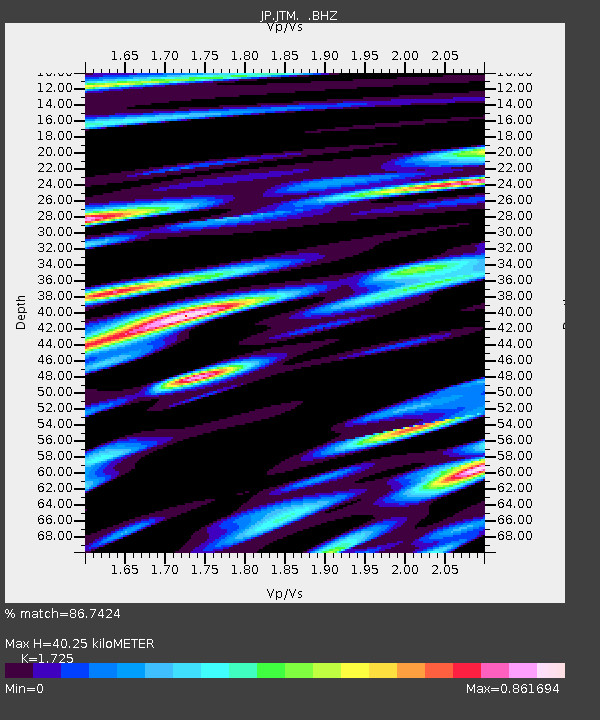
JTM Aomori Tenma - Earthquake Result Viewer
| Earthquake location: |
New Britain Region, P.N.G. |
| Earthquake latitude/longitude: |
-6.0/148.2 |
| Earthquake time(UTC): |
2014/11/07 (311) 03:33:54 GMT |
| Earthquake Depth: |
43 km |
| Earthquake Magnitude: |
6.6 MWW, 6.6 MWB, 6.9 MI |
| Earthquake Catalog/Contributor: |
NEIC PDE/NEIC COMCAT |
|
| Network: |
JP Japan Meteorological Agency Seismic Network |
| Station: |
JTM Aomori Tenma |
| Lat/Lon: |
40.79 N/141.06 E |
| Elevation: |
130 m |
|
| Distance: |
47.1 deg |
| Az: |
352.588 deg |
| Baz: |
170.272 deg |
| Ray Param: |
0.07013152 |
| Estimated Moho Depth: |
40.25 km |
| Estimated Crust Vp/Vs: |
1.73 |
| Assumed Crust Vp: |
6.468 km/s |
| Estimated Crust Vs: |
3.749 km/s |
| Estimated Crust Poisson's Ratio: |
0.25 |
|
| Radial Match: |
86.7424 % |
| Radial Bump: |
400 |
| Transverse Match: |
80.03923 % |
| Transverse Bump: |
400 |
| SOD ConfigId: |
815426 |
| Insert Time: |
2014-11-21 03:51:57.924 +0000 |
| GWidth: |
2.5 |
| Max Bumps: |
400 |
| Tol: |
0.001 |
|

Signal To Noise
| Channel | StoN | STA | LTA |
| JP:JTM: :BHZ:20141107T03:41:51.949987Z | 7.958304 | 4.5055863E-6 | 5.66149E-7 |
| JP:JTM: :BHN:20141107T03:41:51.949987Z | 2.5573006 | 2.2209942E-6 | 8.6849167E-7 |
| JP:JTM: :BHE:20141107T03:41:51.949987Z | 2.8255503 | 7.2203534E-7 | 2.5553797E-7 |
| Arrivals |
| Ps | 4.8 SECOND |
| PpPs | 16 SECOND |
| PsPs/PpSs | 21 SECOND |


