You are here: Home > Network List > TA - USArray Transportable Network (new EarthScope stations) Stations List
> Station O03E Paynes Creek, CA, USA > Earthquake Result Viewer
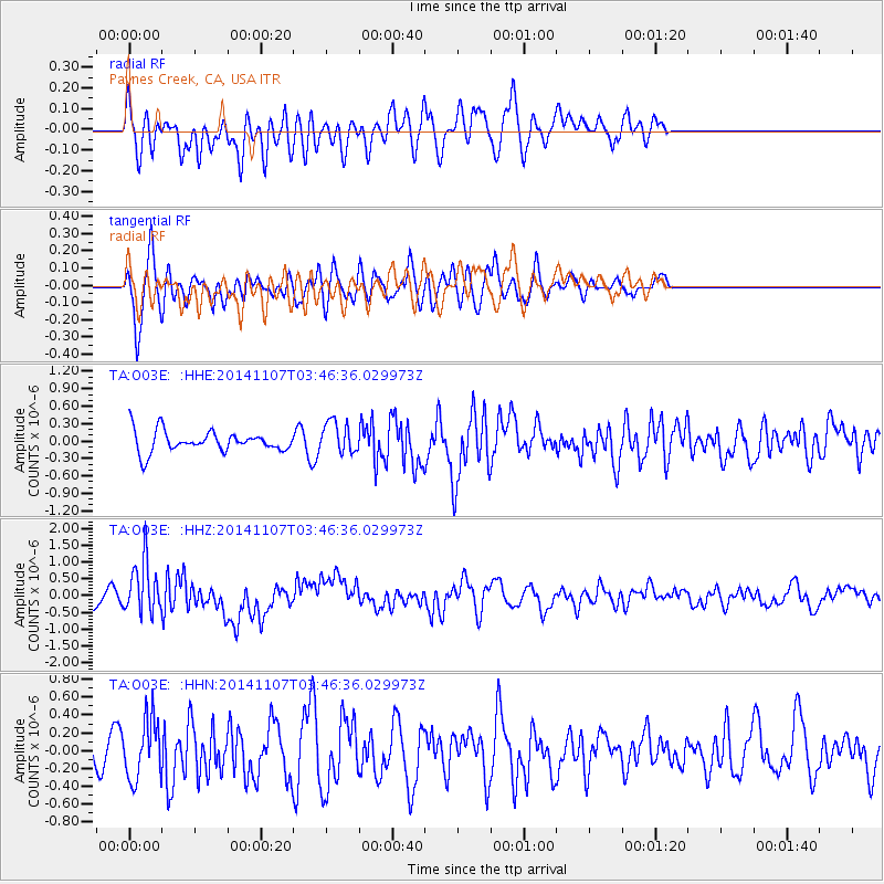
O03E Paynes Creek, CA, USA - Earthquake Result Viewer
*The percent match for this event was below the threshold and hence no stack was calculated.
| Earthquake location: |
New Britain Region, P.N.G. |
| Earthquake latitude/longitude: |
-6.0/148.2 |
| Earthquake time(UTC): |
2014/11/07 (311) 03:33:54 GMT |
| Earthquake Depth: |
43 km |
| Earthquake Magnitude: |
6.6 MWW, 6.6 MWB, 6.9 MI |
| Earthquake Catalog/Contributor: |
NEIC PDE/NEIC COMCAT |
|
| Network: |
TA USArray Transportable Network (new EarthScope stations) |
| Station: |
O03E Paynes Creek, CA, USA |
| Lat/Lon: |
40.29 N/121.80 W |
| Elevation: |
967 m |
|
| Distance: |
93.9 deg |
| Az: |
50.05 deg |
| Baz: |
265.393 deg |
| Ray Param: |
$rayparam |
*The percent match for this event was below the threshold and hence was not used in the summary stack. |
|
| Radial Match: |
51.544327 % |
| Radial Bump: |
400 |
| Transverse Match: |
63.94168 % |
| Transverse Bump: |
400 |
| SOD ConfigId: |
815426 |
| Insert Time: |
2014-11-21 03:55:12.475 +0000 |
| GWidth: |
2.5 |
| Max Bumps: |
400 |
| Tol: |
0.001 |
|
Signal To Noise
| Channel | StoN | STA | LTA |
| TA:O03E: :HHZ:20141107T03:46:36.029973Z | 2.494743 | 7.700534E-7 | 3.0867042E-7 |
| TA:O03E: :HHN:20141107T03:46:36.029973Z | 1.3344516 | 3.3486793E-7 | 2.509405E-7 |
| TA:O03E: :HHE:20141107T03:46:36.029973Z | 1.4941669 | 2.7349031E-7 | 1.8303865E-7 |
| Arrivals |
| Ps | |
| PpPs | |
| PsPs/PpSs | |


