You are here: Home > Network List > TA - USArray Transportable Network (new EarthScope stations) Stations List
> Station A21K Barrow, AK, USA > Earthquake Result Viewer
A21K Barrow, AK, USA - Earthquake Result Viewer
| Earthquake location: |
New Britain Region, P.N.G. |
| Earthquake latitude/longitude: |
-6.0/148.2 |
| Earthquake time(UTC): |
2014/11/07 (311) 03:33:54 GMT |
| Earthquake Depth: |
43 km |
| Earthquake Magnitude: |
6.6 MWW, 6.6 MWB, 6.9 MI |
| Earthquake Catalog/Contributor: |
NEIC PDE/NEIC COMCAT |
|
| Network: |
TA USArray Transportable Network (new EarthScope stations) |
| Station: |
A21K Barrow, AK, USA |
| Lat/Lon: |
71.32 N/156.62 W |
| Elevation: |
577 m |
|
| Distance: |
85.2 deg |
| Az: |
15.391 deg |
| Baz: |
235.012 deg |
| Ray Param: |
0.044879097 |
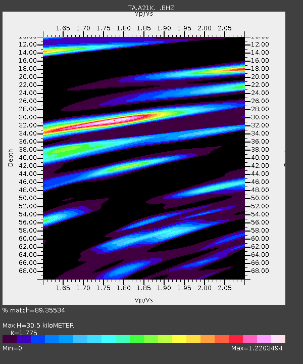
| Estimated Moho Depth: |
30.5 km |
| Estimated Crust Vp/Vs: |
1.77 |
| Assumed Crust Vp: |
6.048 km/s |
| Estimated Crust Vs: |
3.407 km/s |
| Estimated Crust Poisson's Ratio: |
0.27 |
|
| Radial Match: |
89.35534 % |
| Radial Bump: |
400 |
| Transverse Match: |
77.51794 % |
| Transverse Bump: |
400 |
| SOD ConfigId: |
815426 |
| Insert Time: |
2014-11-21 03:55:22.864 +0000 |
| GWidth: |
2.5 |
| Max Bumps: |
400 |
| Tol: |
0.001 |
|
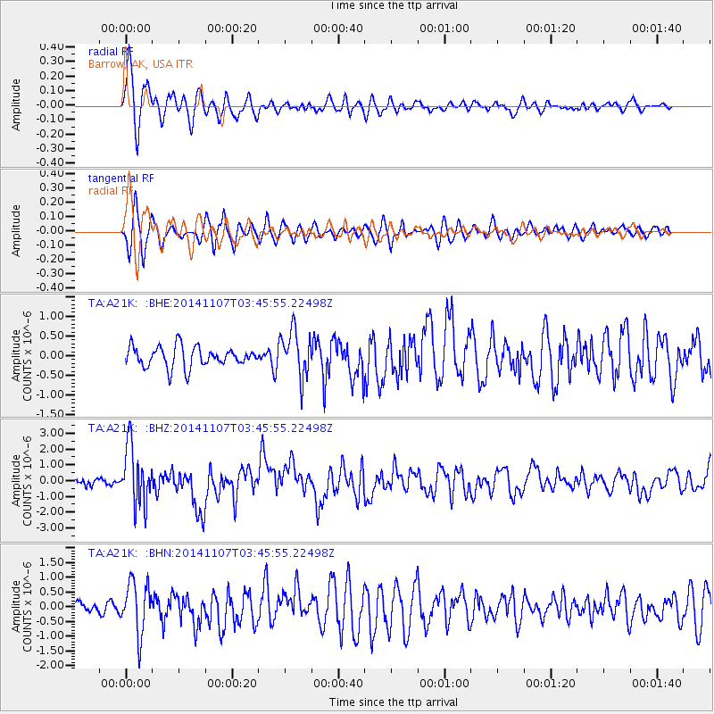
Signal To Noise
| Channel | StoN | STA | LTA |
| TA:A21K: :BHZ:20141107T03:45:55.22498Z | 11.514942 | 1.8729705E-6 | 1.6265567E-7 |
| TA:A21K: :BHN:20141107T03:45:55.22498Z | 4.7374682 | 8.8029856E-7 | 1.8581625E-7 |
| TA:A21K: :BHE:20141107T03:45:55.22498Z | 2.279385 | 5.856467E-7 | 2.5693188E-7 |
| Arrivals |
| Ps | 4.0 SECOND |
| PpPs | 14 SECOND |
| PsPs/PpSs | 18 SECOND |


