You are here: Home > Network List > TA - USArray Transportable Network (new EarthScope stations) Stations List
> Station K27K Chicken, AK, USA > Earthquake Result Viewer
K27K Chicken, AK, USA - Earthquake Result Viewer
| Earthquake location: |
New Britain Region, P.N.G. |
| Earthquake latitude/longitude: |
-6.0/148.2 |
| Earthquake time(UTC): |
2014/11/07 (311) 03:33:54 GMT |
| Earthquake Depth: |
43 km |
| Earthquake Magnitude: |
6.6 MWW, 6.6 MWB, 6.9 MI |
| Earthquake Catalog/Contributor: |
NEIC PDE/NEIC COMCAT |
|
| Network: |
TA USArray Transportable Network (new EarthScope stations) |
| Station: |
K27K Chicken, AK, USA |
| Lat/Lon: |
64.03 N/142.08 W |
| Elevation: |
389 m |
|
| Distance: |
86.7 deg |
| Az: |
24.436 deg |
| Baz: |
249.131 deg |
| Ray Param: |
0.04380745 |
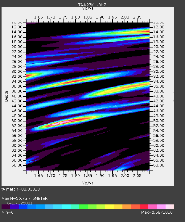
| Estimated Moho Depth: |
50.75 km |
| Estimated Crust Vp/Vs: |
1.73 |
| Assumed Crust Vp: |
6.566 km/s |
| Estimated Crust Vs: |
3.79 km/s |
| Estimated Crust Poisson's Ratio: |
0.25 |
|
| Radial Match: |
88.33013 % |
| Radial Bump: |
400 |
| Transverse Match: |
71.967384 % |
| Transverse Bump: |
400 |
| SOD ConfigId: |
815426 |
| Insert Time: |
2014-11-21 03:55:23.151 +0000 |
| GWidth: |
2.5 |
| Max Bumps: |
400 |
| Tol: |
0.001 |
|

Signal To Noise
| Channel | StoN | STA | LTA |
| TA:K27K: :BHZ:20141107T03:46:02.59998Z | 22.603378 | 2.92044E-6 | 1.292037E-7 |
| TA:K27K: :BHN:20141107T03:46:02.59998Z | 6.179252 | 4.867609E-7 | 7.877343E-8 |
| TA:K27K: :BHE:20141107T03:46:02.59998Z | 8.511257 | 8.9702576E-7 | 1.05392864E-7 |
| Arrivals |
| Ps | 5.8 SECOND |
| PpPs | 21 SECOND |
| PsPs/PpSs | 26 SECOND |


