You are here: Home > Network List > TA - USArray Transportable Network (new EarthScope stations) Stations List
> Station P52A Corning, OH, USA > Earthquake Result Viewer
P52A Corning, OH, USA - Earthquake Result Viewer
| Earthquake location: |
Kuril Islands |
| Earthquake latitude/longitude: |
47.9/153.2 |
| Earthquake time(UTC): |
2015/05/09 (129) 16:34:27 GMT |
| Earthquake Depth: |
125 km |
| Earthquake Magnitude: |
4.5 mb |
| Earthquake Catalog/Contributor: |
ISC/ISC |
|
| Network: |
TA USArray Transportable Network (new EarthScope stations) |
| Station: |
P52A Corning, OH, USA |
| Lat/Lon: |
39.63 N/82.13 W |
| Elevation: |
293 m |
|
| Distance: |
80.0 deg |
| Az: |
40.193 deg |
| Baz: |
325.756 deg |
| Ray Param: |
0.048312623 |
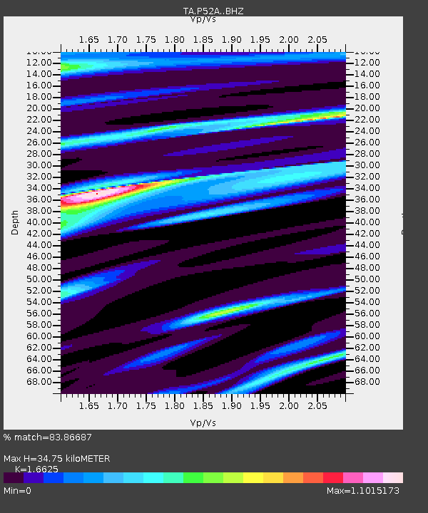
| Estimated Moho Depth: |
34.75 km |
| Estimated Crust Vp/Vs: |
1.66 |
| Assumed Crust Vp: |
6.232 km/s |
| Estimated Crust Vs: |
3.748 km/s |
| Estimated Crust Poisson's Ratio: |
0.22 |
|
| Radial Match: |
83.86687 % |
| Radial Bump: |
400 |
| Transverse Match: |
59.45859 % |
| Transverse Bump: |
400 |
| SOD ConfigId: |
7422571 |
| Insert Time: |
2019-04-18 18:58:43.940 +0000 |
| GWidth: |
2.5 |
| Max Bumps: |
400 |
| Tol: |
0.001 |
|

Signal To Noise
| Channel | StoN | STA | LTA |
| TA:P52A: :BHZ:20150509T16:45:51.899023Z | 2.074276 | 4.1934337E-7 | 2.0216372E-7 |
| TA:P52A: :BHN:20150509T16:45:51.899023Z | 2.4836192 | 3.8830728E-7 | 1.5634735E-7 |
| TA:P52A: :BHE:20150509T16:45:51.899023Z | 1.2582072 | 2.4889044E-7 | 1.9781355E-7 |
| Arrivals |
| Ps | 3.8 SECOND |
| PpPs | 14 SECOND |
| PsPs/PpSs | 18 SECOND |


