You are here: Home > Network List > TA - USArray Transportable Network (new EarthScope stations) Stations List
> Station I23K Minto, Yukon-Koyukuk, AK, USA > Earthquake Result Viewer
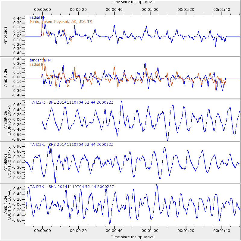
I23K Minto, Yukon-Koyukuk, AK, USA - Earthquake Result Viewer
*The percent match for this event was below the threshold and hence no stack was calculated.
| Earthquake location: |
Philippine Islands Region |
| Earthquake latitude/longitude: |
10.0/126.8 |
| Earthquake time(UTC): |
2014/11/10 (314) 04:41:21 GMT |
| Earthquake Depth: |
64 km |
| Earthquake Magnitude: |
5.5 MB |
| Earthquake Catalog/Contributor: |
NEIC PDE/NEIC COMCAT |
|
| Network: |
TA USArray Transportable Network (new EarthScope stations) |
| Station: |
I23K Minto, Yukon-Koyukuk, AK, USA |
| Lat/Lon: |
65.15 N/149.36 W |
| Elevation: |
149 m |
|
| Distance: |
78.3 deg |
| Az: |
25.402 deg |
| Baz: |
268.634 deg |
| Ray Param: |
$rayparam |
*The percent match for this event was below the threshold and hence was not used in the summary stack. |
|
| Radial Match: |
55.524384 % |
| Radial Bump: |
400 |
| Transverse Match: |
49.578274 % |
| Transverse Bump: |
400 |
| SOD ConfigId: |
815943 |
| Insert Time: |
2014-11-24 05:02:28.204 +0000 |
| GWidth: |
2.5 |
| Max Bumps: |
400 |
| Tol: |
0.001 |
|
Signal To Noise
| Channel | StoN | STA | LTA |
| TA:I23K: :BHZ:20141110T04:52:44.200022Z | 2.5933602 | 6.0410594E-7 | 2.3294332E-7 |
| TA:I23K: :BHN:20141110T04:52:44.200022Z | 0.6993554 | 2.1777822E-7 | 3.1139848E-7 |
| TA:I23K: :BHE:20141110T04:52:44.200022Z | 0.96345013 | 2.5874007E-7 | 2.6855574E-7 |
| Arrivals |
| Ps | |
| PpPs | |
| PsPs/PpSs | |


