You are here: Home > Network List > AK - Alaska Regional Network Stations List
> Station MDM Murphy Dome > Earthquake Result Viewer
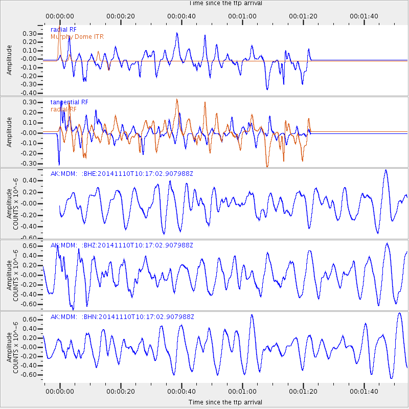
MDM Murphy Dome - Earthquake Result Viewer
*The percent match for this event was below the threshold and hence no stack was calculated.
| Earthquake location: |
Southeast Of Loyalty Islands |
| Earthquake latitude/longitude: |
-22.8/171.4 |
| Earthquake time(UTC): |
2014/11/10 (314) 10:04:21 GMT |
| Earthquake Depth: |
10 km |
| Earthquake Magnitude: |
6.1 MWP |
| Earthquake Catalog/Contributor: |
NEIC PDE/NEIC COMCAT |
|
| Network: |
AK Alaska Regional Network |
| Station: |
MDM Murphy Dome |
| Lat/Lon: |
64.96 N/148.23 W |
| Elevation: |
634 m |
|
| Distance: |
92.8 deg |
| Az: |
16.007 deg |
| Baz: |
216.726 deg |
| Ray Param: |
$rayparam |
*The percent match for this event was below the threshold and hence was not used in the summary stack. |
|
| Radial Match: |
52.982502 % |
| Radial Bump: |
400 |
| Transverse Match: |
55.168983 % |
| Transverse Bump: |
400 |
| SOD ConfigId: |
815943 |
| Insert Time: |
2014-11-24 10:06:55.023 +0000 |
| GWidth: |
2.5 |
| Max Bumps: |
400 |
| Tol: |
0.001 |
|
Signal To Noise
| Channel | StoN | STA | LTA |
| AK:MDM: :BHZ:20141110T10:17:02.907988Z | 1.8049664 | 4.358695E-7 | 2.4148343E-7 |
| AK:MDM: :BHN:20141110T10:17:02.907988Z | 0.5585995 | 1.2135303E-7 | 2.1724516E-7 |
| AK:MDM: :BHE:20141110T10:17:02.907988Z | 1.4370326 | 2.7993167E-7 | 1.947984E-7 |
| Arrivals |
| Ps | |
| PpPs | |
| PsPs/PpSs | |


