You are here: Home > Network List > US - United States National Seismic Network Stations List
> Station MNTX Cornudas Mountains, Texas, USA > Earthquake Result Viewer
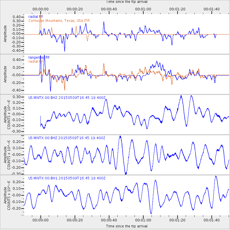
MNTX Cornudas Mountains, Texas, USA - Earthquake Result Viewer
*The percent match for this event was below the threshold and hence no stack was calculated.
| Earthquake location: |
Kuril Islands |
| Earthquake latitude/longitude: |
47.9/153.2 |
| Earthquake time(UTC): |
2015/05/09 (129) 16:34:27 GMT |
| Earthquake Depth: |
125 km |
| Earthquake Magnitude: |
4.5 mb |
| Earthquake Catalog/Contributor: |
ISC/ISC |
|
| Network: |
US United States National Seismic Network |
| Station: |
MNTX Cornudas Mountains, Texas, USA |
| Lat/Lon: |
31.70 N/105.38 W |
| Elevation: |
404 m |
|
| Distance: |
74.1 deg |
| Az: |
60.315 deg |
| Baz: |
316.665 deg |
| Ray Param: |
$rayparam |
*The percent match for this event was below the threshold and hence was not used in the summary stack. |
|
| Radial Match: |
50.435726 % |
| Radial Bump: |
400 |
| Transverse Match: |
28.884663 % |
| Transverse Bump: |
400 |
| SOD ConfigId: |
7422571 |
| Insert Time: |
2019-04-18 18:59:23.882 +0000 |
| GWidth: |
2.5 |
| Max Bumps: |
400 |
| Tol: |
0.001 |
|
Signal To Noise
| Channel | StoN | STA | LTA |
| US:MNTX:00:BHZ:20150509T16:45:19.400Z | 0.6499066 | 6.709774E-8 | 1.0324213E-7 |
| US:MNTX:00:BH1:20150509T16:45:19.400Z | 1.0781353 | 7.541126E-8 | 6.994601E-8 |
| US:MNTX:00:BH2:20150509T16:45:19.400Z | 1.4519771 | 1.074524E-7 | 7.40042E-8 |
| Arrivals |
| Ps | |
| PpPs | |
| PsPs/PpSs | |


