You are here: Home > Network List > TA - USArray Transportable Network (new EarthScope stations) Stations List
> Station O03E Paynes Creek, CA, USA > Earthquake Result Viewer
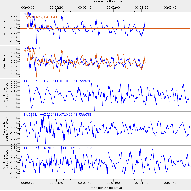
O03E Paynes Creek, CA, USA - Earthquake Result Viewer
*The percent match for this event was below the threshold and hence no stack was calculated.
| Earthquake location: |
Southeast Of Loyalty Islands |
| Earthquake latitude/longitude: |
-22.8/171.4 |
| Earthquake time(UTC): |
2014/11/10 (314) 10:04:21 GMT |
| Earthquake Depth: |
10 km |
| Earthquake Magnitude: |
6.1 MWP |
| Earthquake Catalog/Contributor: |
NEIC PDE/NEIC COMCAT |
|
| Network: |
TA USArray Transportable Network (new EarthScope stations) |
| Station: |
O03E Paynes Creek, CA, USA |
| Lat/Lon: |
40.29 N/121.80 W |
| Elevation: |
967 m |
|
| Distance: |
88.2 deg |
| Az: |
44.676 deg |
| Baz: |
238.04 deg |
| Ray Param: |
$rayparam |
*The percent match for this event was below the threshold and hence was not used in the summary stack. |
|
| Radial Match: |
54.530632 % |
| Radial Bump: |
400 |
| Transverse Match: |
70.593864 % |
| Transverse Bump: |
400 |
| SOD ConfigId: |
815943 |
| Insert Time: |
2014-11-24 10:17:57.319 +0000 |
| GWidth: |
2.5 |
| Max Bumps: |
400 |
| Tol: |
0.001 |
|
Signal To Noise
| Channel | StoN | STA | LTA |
| TA:O03E: :HHZ:20141110T10:16:41.759978Z | 2.0198452 | 6.547645E-7 | 3.2416568E-7 |
| TA:O03E: :HHN:20141110T10:16:41.759978Z | 0.72727627 | 2.327651E-7 | 3.2005048E-7 |
| TA:O03E: :HHE:20141110T10:16:41.759978Z | 0.64295477 | 2.6776502E-7 | 4.1646013E-7 |
| Arrivals |
| Ps | |
| PpPs | |
| PsPs/PpSs | |


