You are here: Home > Network List > WY - Yellowstone Wyoming Seismic Network Stations List
> Station YHR Hawk's Rest, WY, USA > Earthquake Result Viewer
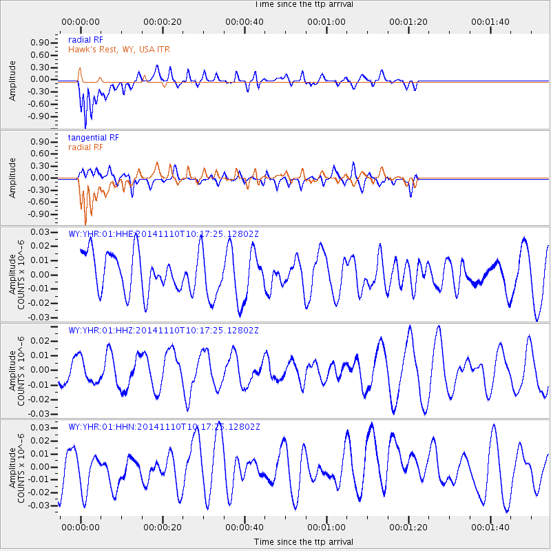
YHR Hawk's Rest, WY, USA - Earthquake Result Viewer
*The percent match for this event was below the threshold and hence no stack was calculated.
| Earthquake location: |
Southeast Of Loyalty Islands |
| Earthquake latitude/longitude: |
-22.8/171.4 |
| Earthquake time(UTC): |
2014/11/10 (314) 10:04:21 GMT |
| Earthquake Depth: |
10 km |
| Earthquake Magnitude: |
6.1 MWP |
| Earthquake Catalog/Contributor: |
NEIC PDE/NEIC COMCAT |
|
| Network: |
WY Yellowstone Wyoming Seismic Network |
| Station: |
YHR Hawk's Rest, WY, USA |
| Lat/Lon: |
44.11 N/110.08 W |
| Elevation: |
2976 m |
|
| Distance: |
97.7 deg |
| Az: |
45.421 deg |
| Baz: |
245.865 deg |
| Ray Param: |
$rayparam |
*The percent match for this event was below the threshold and hence was not used in the summary stack. |
|
| Radial Match: |
74.44166 % |
| Radial Bump: |
400 |
| Transverse Match: |
50.413162 % |
| Transverse Bump: |
400 |
| SOD ConfigId: |
815943 |
| Insert Time: |
2014-11-24 10:19:50.813 +0000 |
| GWidth: |
2.5 |
| Max Bumps: |
400 |
| Tol: |
0.001 |
|
Signal To Noise
| Channel | StoN | STA | LTA |
| WY:YHR:01:HHZ:20141110T10:17:25.12802Z | 0.57237434 | 8.53587E-9 | 1.491309E-8 |
| WY:YHR:01:HHN:20141110T10:17:25.12802Z | 1.1315275 | 1.8857673E-8 | 1.6665677E-8 |
| WY:YHR:01:HHE:20141110T10:17:25.12802Z | 1.3007874 | 1.7565721E-8 | 1.35039135E-8 |
| Arrivals |
| Ps | |
| PpPs | |
| PsPs/PpSs | |


