You are here: Home > Network List > TA - USArray Transportable Network (new EarthScope stations) Stations List
> Station G59A Clarenceville, QC, USA > Earthquake Result Viewer
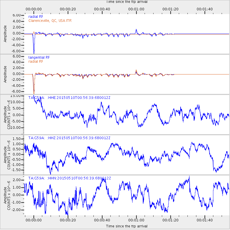
G59A Clarenceville, QC, USA - Earthquake Result Viewer
*The percent match for this event was below the threshold and hence no stack was calculated.
| Earthquake location: |
Near Coast Of Chiapas, Mexico |
| Earthquake latitude/longitude: |
14.9/-94.0 |
| Earthquake time(UTC): |
2015/05/10 (130) 00:50:18 GMT |
| Earthquake Depth: |
6.7 km |
| Earthquake Magnitude: |
5.6 MB |
| Earthquake Catalog/Contributor: |
NEIC PDE/NEIC COMCAT |
|
| Network: |
TA USArray Transportable Network (new EarthScope stations) |
| Station: |
G59A Clarenceville, QC, USA |
| Lat/Lon: |
45.08 N/73.18 W |
| Elevation: |
36 m |
|
| Distance: |
34.9 deg |
| Az: |
26.11 deg |
| Baz: |
216.916 deg |
| Ray Param: |
$rayparam |
*The percent match for this event was below the threshold and hence was not used in the summary stack. |
|
| Radial Match: |
61.680225 % |
| Radial Bump: |
290 |
| Transverse Match: |
74.38642 % |
| Transverse Bump: |
224 |
| SOD ConfigId: |
7422571 |
| Insert Time: |
2019-04-18 19:03:56.201 +0000 |
| GWidth: |
2.5 |
| Max Bumps: |
400 |
| Tol: |
0.001 |
|
Signal To Noise
| Channel | StoN | STA | LTA |
| TA:G59A: :HHZ:20150510T00:56:39.680012Z | 0.72786146 | 3.5037792E-7 | 4.8137997E-7 |
| TA:G59A: :HHN:20150510T00:56:39.680012Z | 1.9513112 | 2.208389E-6 | 1.1317462E-6 |
| TA:G59A: :HHE:20150510T00:56:39.680012Z | 1.4096805 | 6.677331E-6 | 4.736769E-6 |
| Arrivals |
| Ps | |
| PpPs | |
| PsPs/PpSs | |


