You are here: Home > Network List > TA - USArray Transportable Network (new EarthScope stations) Stations List
> Station T56A Rocky Mt, VA, USA > Earthquake Result Viewer
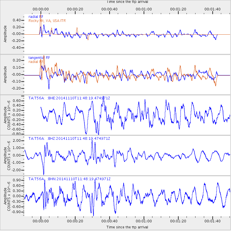
T56A Rocky Mt, VA, USA - Earthquake Result Viewer
*The percent match for this event was below the threshold and hence no stack was calculated.
| Earthquake location: |
Chile-Bolivia Border Region |
| Earthquake latitude/longitude: |
-21.6/-68.5 |
| Earthquake time(UTC): |
2014/11/10 (314) 11:38:58 GMT |
| Earthquake Depth: |
104 km |
| Earthquake Magnitude: |
5.8 MB |
| Earthquake Catalog/Contributor: |
NEIC PDE/NEIC COMCAT |
|
| Network: |
TA USArray Transportable Network (new EarthScope stations) |
| Station: |
T56A Rocky Mt, VA, USA |
| Lat/Lon: |
37.03 N/80.03 W |
| Elevation: |
387 m |
|
| Distance: |
59.4 deg |
| Az: |
349.304 deg |
| Baz: |
167.54 deg |
| Ray Param: |
$rayparam |
*The percent match for this event was below the threshold and hence was not used in the summary stack. |
|
| Radial Match: |
49.851364 % |
| Radial Bump: |
400 |
| Transverse Match: |
59.042675 % |
| Transverse Bump: |
400 |
| SOD ConfigId: |
815943 |
| Insert Time: |
2014-11-24 12:09:05.467 +0000 |
| GWidth: |
2.5 |
| Max Bumps: |
400 |
| Tol: |
0.001 |
|
Signal To Noise
| Channel | StoN | STA | LTA |
| TA:T56A: :BHZ:20141110T11:48:19.474971Z | 2.854929 | 1.027249E-6 | 3.59816E-7 |
| TA:T56A: :BHN:20141110T11:48:19.474971Z | 2.585181 | 3.466748E-7 | 1.3410079E-7 |
| TA:T56A: :BHE:20141110T11:48:19.474971Z | 2.3277187 | 4.7281063E-7 | 2.0312189E-7 |
| Arrivals |
| Ps | |
| PpPs | |
| PsPs/PpSs | |


