You are here: Home > Network List > UW - Pacific Northwest Regional Seismic Network Stations List
> Station UMAT Pilot Rock, OR, USA > Earthquake Result Viewer
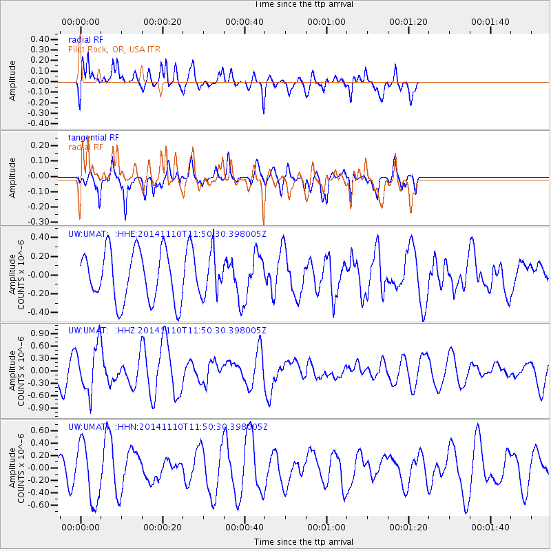
UMAT Pilot Rock, OR, USA - Earthquake Result Viewer
*The percent match for this event was below the threshold and hence no stack was calculated.
| Earthquake location: |
Chile-Bolivia Border Region |
| Earthquake latitude/longitude: |
-21.6/-68.5 |
| Earthquake time(UTC): |
2014/11/10 (314) 11:38:58 GMT |
| Earthquake Depth: |
104 km |
| Earthquake Magnitude: |
5.8 MB |
| Earthquake Catalog/Contributor: |
NEIC PDE/NEIC COMCAT |
|
| Network: |
UW Pacific Northwest Regional Seismic Network |
| Station: |
UMAT Pilot Rock, OR, USA |
| Lat/Lon: |
45.29 N/118.96 W |
| Elevation: |
1318 m |
|
| Distance: |
80.9 deg |
| Az: |
326.552 deg |
| Baz: |
133.412 deg |
| Ray Param: |
$rayparam |
*The percent match for this event was below the threshold and hence was not used in the summary stack. |
|
| Radial Match: |
72.071144 % |
| Radial Bump: |
400 |
| Transverse Match: |
54.190994 % |
| Transverse Bump: |
374 |
| SOD ConfigId: |
815943 |
| Insert Time: |
2014-11-24 12:12:30.741 +0000 |
| GWidth: |
2.5 |
| Max Bumps: |
400 |
| Tol: |
0.001 |
|
Signal To Noise
| Channel | StoN | STA | LTA |
| UW:UMAT: :HHZ:20141110T11:50:30.398005Z | 1.590167 | 5.661869E-7 | 3.5605495E-7 |
| UW:UMAT: :HHN:20141110T11:50:30.398005Z | 1.2139531 | 4.793497E-7 | 3.9486673E-7 |
| UW:UMAT: :HHE:20141110T11:50:30.398005Z | 0.80660826 | 2.1754278E-7 | 2.6970065E-7 |
| Arrivals |
| Ps | |
| PpPs | |
| PsPs/PpSs | |


