You are here: Home > Network List > XD14 - Illuminating the architecture of the greater Mount St. Helens magmatic systems f Stations List
> Station MG07 "Mount St Helens, WA" > Earthquake Result Viewer
MG07 "Mount St Helens, WA" - Earthquake Result Viewer
| Earthquake location: |
Near Coast Of Chiapas, Mexico |
| Earthquake latitude/longitude: |
14.9/-94.0 |
| Earthquake time(UTC): |
2015/05/10 (130) 00:50:18 GMT |
| Earthquake Depth: |
6.7 km |
| Earthquake Magnitude: |
5.6 MB |
| Earthquake Catalog/Contributor: |
NEIC PDE/NEIC COMCAT |
|
| Network: |
XD Illuminating the architecture of the greater Mount St. Helens magmatic systems f |
| Station: |
MG07 "Mount St Helens, WA" |
| Lat/Lon: |
46.35 N/122.03 W |
| Elevation: |
1457 m |
|
| Distance: |
39.2 deg |
| Az: |
328.985 deg |
| Baz: |
134.001 deg |
| Ray Param: |
0.075134225 |
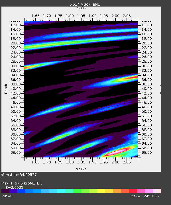
| Estimated Moho Depth: |
67.5 km |
| Estimated Crust Vp/Vs: |
2.00 |
| Assumed Crust Vp: |
6.566 km/s |
| Estimated Crust Vs: |
3.279 km/s |
| Estimated Crust Poisson's Ratio: |
0.33 |
|
| Radial Match: |
84.00577 % |
| Radial Bump: |
400 |
| Transverse Match: |
43.56201 % |
| Transverse Bump: |
400 |
| SOD ConfigId: |
7422571 |
| Insert Time: |
2019-04-18 19:05:24.086 +0000 |
| GWidth: |
2.5 |
| Max Bumps: |
400 |
| Tol: |
0.001 |
|

Signal To Noise
| Channel | StoN | STA | LTA |
| XD:MG07: :BHZ:20150510T00:57:15.194996Z | 9.790504 | 6.4476404E-7 | 6.585606E-8 |
| XD:MG07: :BHN:20150510T00:57:15.194996Z | 1.186532 | 2.5983297E-7 | 2.189852E-7 |
| XD:MG07: :BHE:20150510T00:57:15.194996Z | 3.121115 | 2.6787154E-7 | 8.58256E-8 |
| Arrivals |
| Ps | 11 SECOND |
| PpPs | 29 SECOND |
| PsPs/PpSs | 40 SECOND |


