You are here: Home > Network List > XD14 - Illuminating the architecture of the greater Mount St. Helens magmatic systems f Stations List
> Station MH01 "Mount St Helens, WA" > Earthquake Result Viewer
MH01 "Mount St Helens, WA" - Earthquake Result Viewer
| Earthquake location: |
Near Coast Of Chiapas, Mexico |
| Earthquake latitude/longitude: |
14.9/-94.0 |
| Earthquake time(UTC): |
2015/05/10 (130) 00:50:18 GMT |
| Earthquake Depth: |
6.7 km |
| Earthquake Magnitude: |
5.6 MB |
| Earthquake Catalog/Contributor: |
NEIC PDE/NEIC COMCAT |
|
| Network: |
XD Illuminating the architecture of the greater Mount St. Helens magmatic systems f |
| Station: |
MH01 "Mount St Helens, WA" |
| Lat/Lon: |
46.26 N/122.81 W |
| Elevation: |
197 m |
|
| Distance: |
39.5 deg |
| Az: |
328.301 deg |
| Baz: |
132.913 deg |
| Ray Param: |
0.07494422 |
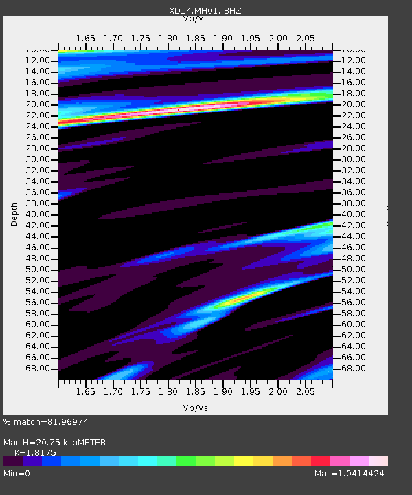
| Estimated Moho Depth: |
20.75 km |
| Estimated Crust Vp/Vs: |
1.82 |
| Assumed Crust Vp: |
6.566 km/s |
| Estimated Crust Vs: |
3.613 km/s |
| Estimated Crust Poisson's Ratio: |
0.28 |
|
| Radial Match: |
81.96974 % |
| Radial Bump: |
341 |
| Transverse Match: |
64.79354 % |
| Transverse Bump: |
400 |
| SOD ConfigId: |
7422571 |
| Insert Time: |
2019-04-18 19:05:26.140 +0000 |
| GWidth: |
2.5 |
| Max Bumps: |
400 |
| Tol: |
0.001 |
|

Signal To Noise
| Channel | StoN | STA | LTA |
| XD:MH01: :BHZ:20150510T00:57:17.930012Z | 7.107966 | 8.987755E-7 | 1.2644622E-7 |
| XD:MH01: :BHN:20150510T00:57:17.930012Z | 1.5276605 | 1.9977088E-7 | 1.3076917E-7 |
| XD:MH01: :BHE:20150510T00:57:17.930012Z | 2.6470633 | 3.0038572E-7 | 1.13478855E-7 |
| Arrivals |
| Ps | 2.8 SECOND |
| PpPs | 8.3 SECOND |
| PsPs/PpSs | 11 SECOND |


