You are here: Home > Network List > XD14 - Illuminating the architecture of the greater Mount St. Helens magmatic systems f Stations List
> Station MN10 "Mount St Helens, WA" > Earthquake Result Viewer
MN10 "Mount St Helens, WA" - Earthquake Result Viewer
| Earthquake location: |
Near Coast Of Chiapas, Mexico |
| Earthquake latitude/longitude: |
14.9/-94.0 |
| Earthquake time(UTC): |
2015/05/10 (130) 00:50:18 GMT |
| Earthquake Depth: |
6.7 km |
| Earthquake Magnitude: |
5.6 MB |
| Earthquake Catalog/Contributor: |
NEIC PDE/NEIC COMCAT |
|
| Network: |
XD Illuminating the architecture of the greater Mount St. Helens magmatic systems f |
| Station: |
MN10 "Mount St Helens, WA" |
| Lat/Lon: |
45.98 N/121.68 W |
| Elevation: |
1091 m |
|
| Distance: |
38.8 deg |
| Az: |
328.831 deg |
| Baz: |
134.133 deg |
| Ray Param: |
0.07538454 |
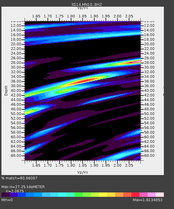
| Estimated Moho Depth: |
27.25 km |
| Estimated Crust Vp/Vs: |
2.10 |
| Assumed Crust Vp: |
6.597 km/s |
| Estimated Crust Vs: |
3.145 km/s |
| Estimated Crust Poisson's Ratio: |
0.35 |
|
| Radial Match: |
90.86087 % |
| Radial Bump: |
400 |
| Transverse Match: |
79.86373 % |
| Transverse Bump: |
400 |
| SOD ConfigId: |
7422571 |
| Insert Time: |
2019-04-18 19:05:53.278 +0000 |
| GWidth: |
2.5 |
| Max Bumps: |
400 |
| Tol: |
0.001 |
|

Signal To Noise
| Channel | StoN | STA | LTA |
| XD:MN10: :BHZ:20150510T00:57:11.580006Z | 11.261905 | 1.0358937E-6 | 9.19821E-8 |
| XD:MN10: :BHN:20150510T00:57:11.580006Z | 2.9587467 | 3.4328744E-7 | 1.16024616E-7 |
| XD:MN10: :BHE:20150510T00:57:11.580006Z | 5.577758 | 4.5920712E-7 | 8.232826E-8 |
| Arrivals |
| Ps | 4.8 SECOND |
| PpPs | 12 SECOND |
| PsPs/PpSs | 17 SECOND |


