You are here: Home > Network List > AV - Alaska Volcano Observatory Stations List
> Station SPCR Ckakachatna River, Mount Spurr, Alaska > Earthquake Result Viewer
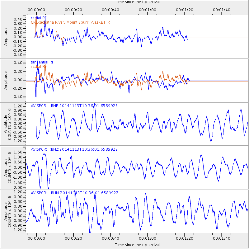
SPCR Ckakachatna River, Mount Spurr, Alaska - Earthquake Result Viewer
*The percent match for this event was below the threshold and hence no stack was calculated.
| Earthquake location: |
Fiji Islands Region |
| Earthquake latitude/longitude: |
-15.2/173.1 |
| Earthquake time(UTC): |
2014/11/13 (317) 10:24:18 GMT |
| Earthquake Depth: |
10 km |
| Earthquake Magnitude: |
5.7 MB |
| Earthquake Catalog/Contributor: |
NEIC PDE/NEIC COMCAT |
|
| Network: |
AV Alaska Volcano Observatory |
| Station: |
SPCR Ckakachatna River, Mount Spurr, Alaska |
| Lat/Lon: |
61.20 N/152.21 W |
| Elevation: |
984 m |
|
| Distance: |
81.0 deg |
| Az: |
16.224 deg |
| Baz: |
213.857 deg |
| Ray Param: |
$rayparam |
*The percent match for this event was below the threshold and hence was not used in the summary stack. |
|
| Radial Match: |
73.79544 % |
| Radial Bump: |
400 |
| Transverse Match: |
59.102486 % |
| Transverse Bump: |
400 |
| SOD ConfigId: |
816305 |
| Insert Time: |
2014-11-27 10:32:55.767 +0000 |
| GWidth: |
2.5 |
| Max Bumps: |
400 |
| Tol: |
0.001 |
|
Signal To Noise
| Channel | StoN | STA | LTA |
| AV:SPCR: :BHZ:20141113T10:36:01.658992Z | 1.8480843 | 1.0694397E-6 | 5.7867476E-7 |
| AV:SPCR: :BHN:20141113T10:36:01.658992Z | 1.1986072 | 5.203266E-7 | 4.341093E-7 |
| AV:SPCR: :BHE:20141113T10:36:01.658992Z | 1.2251673 | 6.9500624E-7 | 5.672745E-7 |
| Arrivals |
| Ps | |
| PpPs | |
| PsPs/PpSs | |


