You are here: Home > Network List > TA - USArray Transportable Network (new EarthScope stations) Stations List
> Station 121A Cookes Peak, Deming, NM, USA > Earthquake Result Viewer
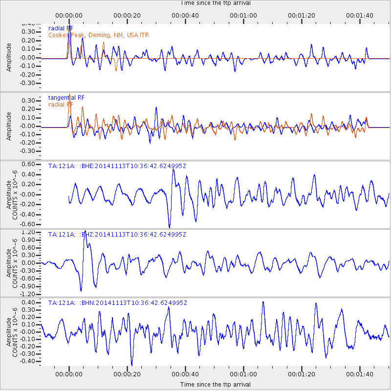
121A Cookes Peak, Deming, NM, USA - Earthquake Result Viewer
*The percent match for this event was below the threshold and hence no stack was calculated.
| Earthquake location: |
Fiji Islands Region |
| Earthquake latitude/longitude: |
-15.2/173.1 |
| Earthquake time(UTC): |
2014/11/13 (317) 10:24:18 GMT |
| Earthquake Depth: |
10 km |
| Earthquake Magnitude: |
5.7 MB |
| Earthquake Catalog/Contributor: |
NEIC PDE/NEIC COMCAT |
|
| Network: |
TA USArray Transportable Network (new EarthScope stations) |
| Station: |
121A Cookes Peak, Deming, NM, USA |
| Lat/Lon: |
32.53 N/107.79 W |
| Elevation: |
1652 m |
|
| Distance: |
89.2 deg |
| Az: |
56.072 deg |
| Baz: |
251.529 deg |
| Ray Param: |
$rayparam |
*The percent match for this event was below the threshold and hence was not used in the summary stack. |
|
| Radial Match: |
65.762726 % |
| Radial Bump: |
400 |
| Transverse Match: |
65.12478 % |
| Transverse Bump: |
400 |
| SOD ConfigId: |
816305 |
| Insert Time: |
2014-11-27 10:43:56.997 +0000 |
| GWidth: |
2.5 |
| Max Bumps: |
400 |
| Tol: |
0.001 |
|
Signal To Noise
| Channel | StoN | STA | LTA |
| TA:121A: :BHZ:20141113T10:36:42.624995Z | 4.1279397 | 4.058316E-7 | 9.831336E-8 |
| TA:121A: :BHN:20141113T10:36:42.624995Z | 0.59462875 | 6.292684E-8 | 1.0582543E-7 |
| TA:121A: :BHE:20141113T10:36:42.624995Z | 1.9427187 | 2.2901156E-7 | 1.17881996E-7 |
| Arrivals |
| Ps | |
| PpPs | |
| PsPs/PpSs | |


