You are here: Home > Network List > TA - USArray Transportable Network (new EarthScope stations) Stations List
> Station R11A Troy Canyon, Currant, NV, USA > Earthquake Result Viewer
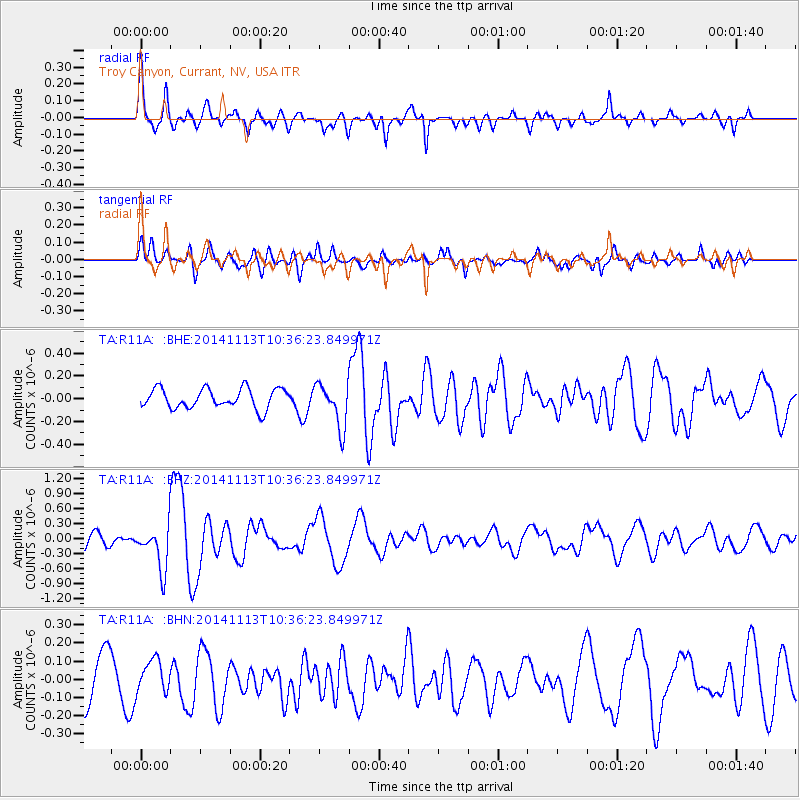
R11A Troy Canyon, Currant, NV, USA - Earthquake Result Viewer
*The percent match for this event was below the threshold and hence no stack was calculated.
| Earthquake location: |
Fiji Islands Region |
| Earthquake latitude/longitude: |
-15.2/173.1 |
| Earthquake time(UTC): |
2014/11/13 (317) 10:24:18 GMT |
| Earthquake Depth: |
10 km |
| Earthquake Magnitude: |
5.7 MB |
| Earthquake Catalog/Contributor: |
NEIC PDE/NEIC COMCAT |
|
| Network: |
TA USArray Transportable Network (new EarthScope stations) |
| Station: |
R11A Troy Canyon, Currant, NV, USA |
| Lat/Lon: |
38.35 N/115.59 W |
| Elevation: |
1756 m |
|
| Distance: |
85.3 deg |
| Az: |
48.379 deg |
| Baz: |
246.644 deg |
| Ray Param: |
$rayparam |
*The percent match for this event was below the threshold and hence was not used in the summary stack. |
|
| Radial Match: |
78.26638 % |
| Radial Bump: |
352 |
| Transverse Match: |
65.56924 % |
| Transverse Bump: |
400 |
| SOD ConfigId: |
816305 |
| Insert Time: |
2014-11-27 10:45:07.719 +0000 |
| GWidth: |
2.5 |
| Max Bumps: |
400 |
| Tol: |
0.001 |
|
Signal To Noise
| Channel | StoN | STA | LTA |
| TA:R11A: :BHZ:20141113T10:36:23.849971Z | 3.3595557 | 4.4375304E-7 | 1.3208683E-7 |
| TA:R11A: :BHN:20141113T10:36:23.849971Z | 0.9473269 | 8.6354135E-8 | 9.115558E-8 |
| TA:R11A: :BHE:20141113T10:36:23.849971Z | 2.2217546 | 1.9277212E-7 | 8.6765716E-8 |
| Arrivals |
| Ps | |
| PpPs | |
| PsPs/PpSs | |


