You are here: Home > Network List > US - United States National Seismic Network Stations List
> Station AMTX Amarillo, Texas, USA > Earthquake Result Viewer
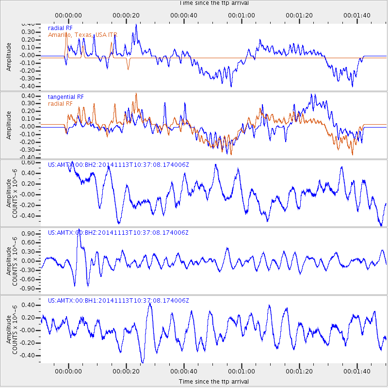
AMTX Amarillo, Texas, USA - Earthquake Result Viewer
*The percent match for this event was below the threshold and hence no stack was calculated.
| Earthquake location: |
Fiji Islands Region |
| Earthquake latitude/longitude: |
-15.2/173.1 |
| Earthquake time(UTC): |
2014/11/13 (317) 10:24:18 GMT |
| Earthquake Depth: |
10 km |
| Earthquake Magnitude: |
5.7 MB |
| Earthquake Catalog/Contributor: |
NEIC PDE/NEIC COMCAT |
|
| Network: |
US United States National Seismic Network |
| Station: |
AMTX Amarillo, Texas, USA |
| Lat/Lon: |
34.53 N/101.41 W |
| Elevation: |
1010 m |
|
| Distance: |
94.9 deg |
| Az: |
55.697 deg |
| Baz: |
255.051 deg |
| Ray Param: |
$rayparam |
*The percent match for this event was below the threshold and hence was not used in the summary stack. |
|
| Radial Match: |
23.047394 % |
| Radial Bump: |
400 |
| Transverse Match: |
23.443563 % |
| Transverse Bump: |
400 |
| SOD ConfigId: |
816305 |
| Insert Time: |
2014-11-27 10:46:04.990 +0000 |
| GWidth: |
2.5 |
| Max Bumps: |
400 |
| Tol: |
0.001 |
|
Signal To Noise
| Channel | StoN | STA | LTA |
| US:AMTX:00:BHZ:20141113T10:37:08.174006Z | 4.9045324 | 5.3354046E-7 | 1.0878518E-7 |
| US:AMTX:00:BH1:20141113T10:37:08.174006Z | 1.0148634 | 1.8038934E-7 | 1.7774741E-7 |
| US:AMTX:00:BH2:20141113T10:37:08.174006Z | 0.99512976 | 2.9210514E-7 | 2.9353473E-7 |
| Arrivals |
| Ps | |
| PpPs | |
| PsPs/PpSs | |


