You are here: Home > Network List > US - United States National Seismic Network Stations List
> Station DUG Dugway, Tooele County, Utah, USA > Earthquake Result Viewer
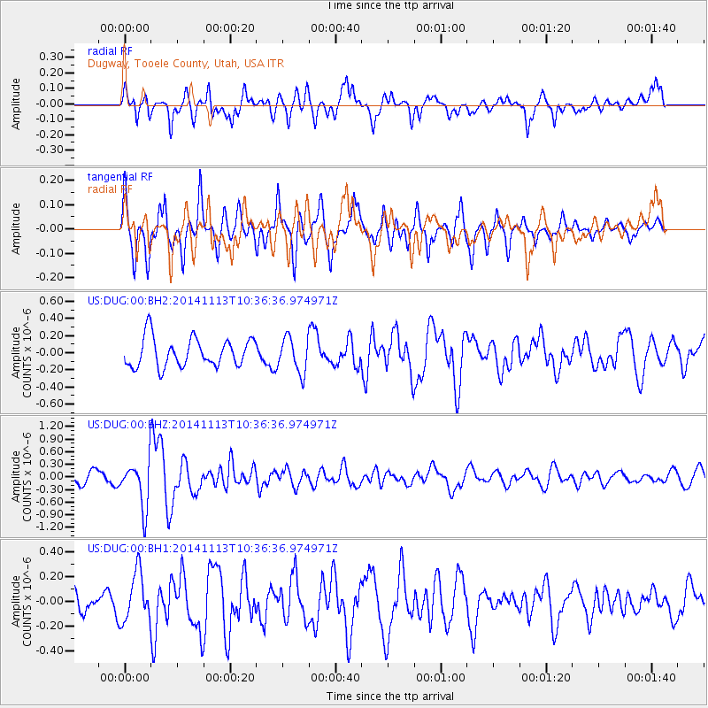
DUG Dugway, Tooele County, Utah, USA - Earthquake Result Viewer
*The percent match for this event was below the threshold and hence no stack was calculated.
| Earthquake location: |
Fiji Islands Region |
| Earthquake latitude/longitude: |
-15.2/173.1 |
| Earthquake time(UTC): |
2014/11/13 (317) 10:24:18 GMT |
| Earthquake Depth: |
10 km |
| Earthquake Magnitude: |
5.7 MB |
| Earthquake Catalog/Contributor: |
NEIC PDE/NEIC COMCAT |
|
| Network: |
US United States National Seismic Network |
| Station: |
DUG Dugway, Tooele County, Utah, USA |
| Lat/Lon: |
40.19 N/112.81 W |
| Elevation: |
1477 m |
|
| Distance: |
88.0 deg |
| Az: |
47.498 deg |
| Baz: |
248.341 deg |
| Ray Param: |
$rayparam |
*The percent match for this event was below the threshold and hence was not used in the summary stack. |
|
| Radial Match: |
63.411934 % |
| Radial Bump: |
400 |
| Transverse Match: |
62.678833 % |
| Transverse Bump: |
400 |
| SOD ConfigId: |
816305 |
| Insert Time: |
2014-11-27 10:46:19.540 +0000 |
| GWidth: |
2.5 |
| Max Bumps: |
400 |
| Tol: |
0.001 |
|
Signal To Noise
| Channel | StoN | STA | LTA |
| US:DUG:00:BHZ:20141113T10:36:36.974971Z | 4.7019362 | 5.5359146E-7 | 1.1773691E-7 |
| US:DUG:00:BH1:20141113T10:36:36.974971Z | 1.1817211 | 2.0010435E-7 | 1.6933298E-7 |
| US:DUG:00:BH2:20141113T10:36:36.974971Z | 1.2230462 | 2.0597028E-7 | 1.6840761E-7 |
| Arrivals |
| Ps | |
| PpPs | |
| PsPs/PpSs | |


