You are here: Home > Network List > UW - Pacific Northwest Regional Seismic Network Stations List
> Station HOOD Mt Hood Meadows, OR CREST BB SMO > Earthquake Result Viewer
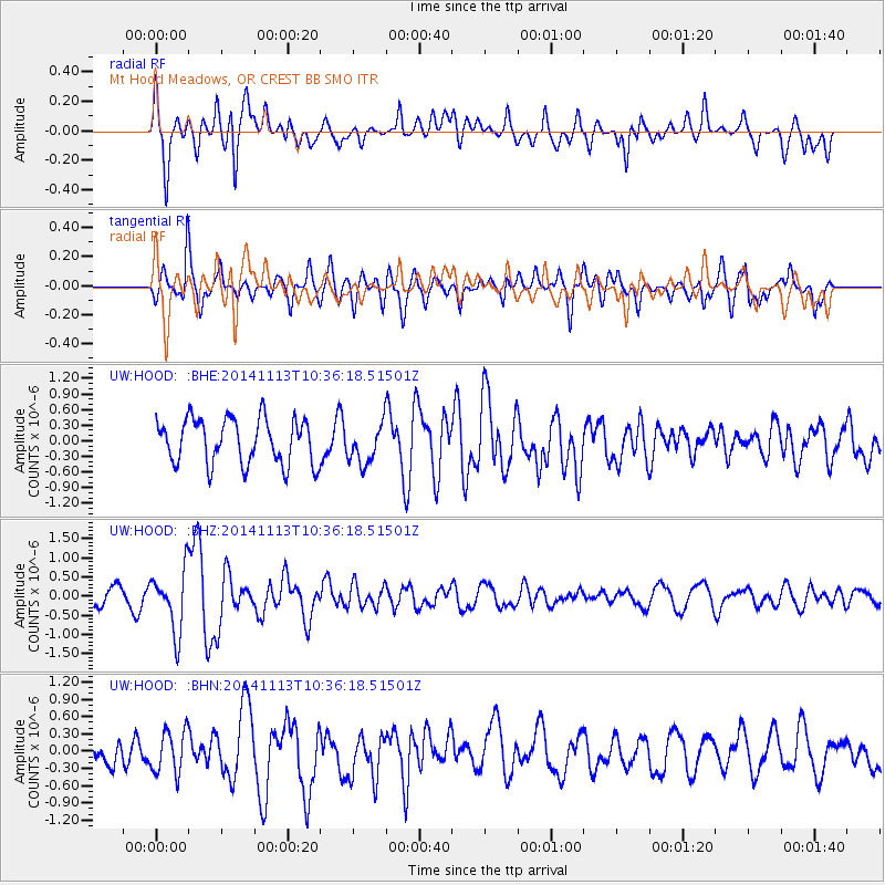
HOOD Mt Hood Meadows, OR CREST BB SMO - Earthquake Result Viewer
*The percent match for this event was below the threshold and hence no stack was calculated.
| Earthquake location: |
Fiji Islands Region |
| Earthquake latitude/longitude: |
-15.2/173.1 |
| Earthquake time(UTC): |
2014/11/13 (317) 10:24:18 GMT |
| Earthquake Depth: |
10 km |
| Earthquake Magnitude: |
5.7 MB |
| Earthquake Catalog/Contributor: |
NEIC PDE/NEIC COMCAT |
|
| Network: |
UW Pacific Northwest Regional Seismic Network |
| Station: |
HOOD Mt Hood Meadows, OR CREST BB SMO |
| Lat/Lon: |
45.32 N/121.65 W |
| Elevation: |
1520 m |
|
| Distance: |
84.2 deg |
| Az: |
40.105 deg |
| Baz: |
241.846 deg |
| Ray Param: |
$rayparam |
*The percent match for this event was below the threshold and hence was not used in the summary stack. |
|
| Radial Match: |
74.72647 % |
| Radial Bump: |
400 |
| Transverse Match: |
75.107254 % |
| Transverse Bump: |
400 |
| SOD ConfigId: |
816305 |
| Insert Time: |
2014-11-27 10:48:39.500 +0000 |
| GWidth: |
2.5 |
| Max Bumps: |
400 |
| Tol: |
0.001 |
|
Signal To Noise
| Channel | StoN | STA | LTA |
| UW:HOOD: :BHZ:20141113T10:36:18.51501Z | 2.0979855 | 8.0852E-7 | 3.853792E-7 |
| UW:HOOD: :BHN:20141113T10:36:18.51501Z | 1.3672895 | 3.7873951E-7 | 2.7700023E-7 |
| UW:HOOD: :BHE:20141113T10:36:18.51501Z | 0.90255773 | 3.8820292E-7 | 4.3011423E-7 |
| Arrivals |
| Ps | |
| PpPs | |
| PsPs/PpSs | |


