You are here: Home > Network List > US - United States National Seismic Network Stations List
> Station MNTX Cornudas Mountains, Texas, USA > Earthquake Result Viewer
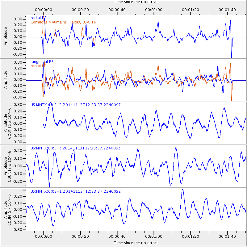
MNTX Cornudas Mountains, Texas, USA - Earthquake Result Viewer
*The percent match for this event was below the threshold and hence no stack was calculated.
| Earthquake location: |
Vanuatu Islands |
| Earthquake latitude/longitude: |
-18.5/169.1 |
| Earthquake time(UTC): |
2014/11/13 (317) 12:21:07 GMT |
| Earthquake Depth: |
218 km |
| Earthquake Magnitude: |
5.5 MB |
| Earthquake Catalog/Contributor: |
NEIC PDE/NEIC COMCAT |
|
| Network: |
US United States National Seismic Network |
| Station: |
MNTX Cornudas Mountains, Texas, USA |
| Lat/Lon: |
31.70 N/105.38 W |
| Elevation: |
404 m |
|
| Distance: |
95.9 deg |
| Az: |
58.682 deg |
| Baz: |
252.012 deg |
| Ray Param: |
$rayparam |
*The percent match for this event was below the threshold and hence was not used in the summary stack. |
|
| Radial Match: |
35.80874 % |
| Radial Bump: |
373 |
| Transverse Match: |
47.558895 % |
| Transverse Bump: |
400 |
| SOD ConfigId: |
816828 |
| Insert Time: |
2014-11-27 12:37:28.392 +0000 |
| GWidth: |
2.5 |
| Max Bumps: |
400 |
| Tol: |
0.001 |
|
Signal To Noise
| Channel | StoN | STA | LTA |
| US:MNTX:00:BHZ:20141113T12:33:37.224009Z | 1.0234944 | 1.1780807E-7 | 1.1510379E-7 |
| US:MNTX:00:BH1:20141113T12:33:37.224009Z | 1.0924081 | 8.590159E-8 | 7.8635075E-8 |
| US:MNTX:00:BH2:20141113T12:33:37.224009Z | 0.8644632 | 8.7079634E-8 | 1.00732606E-7 |
| Arrivals |
| Ps | |
| PpPs | |
| PsPs/PpSs | |


