You are here: Home > Network List > TA - USArray Transportable Network (new EarthScope stations) Stations List
> Station I61A Oroboro, Fairlee, VT, USA > Earthquake Result Viewer
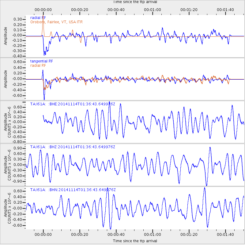
I61A Oroboro, Fairlee, VT, USA - Earthquake Result Viewer
*The percent match for this event was below the threshold and hence no stack was calculated.
| Earthquake location: |
Lake Issyk-Kul Region |
| Earthquake latitude/longitude: |
42.1/77.3 |
| Earthquake time(UTC): |
2014/11/14 (318) 01:24:15 GMT |
| Earthquake Depth: |
10 km |
| Earthquake Magnitude: |
5.5 MB, 5.2 MWB |
| Earthquake Catalog/Contributor: |
NEIC PDE/NEIC COMCAT |
|
| Network: |
TA USArray Transportable Network (new EarthScope stations) |
| Station: |
I61A Oroboro, Fairlee, VT, USA |
| Lat/Lon: |
43.93 N/72.21 W |
| Elevation: |
287 m |
|
| Distance: |
90.1 deg |
| Az: |
338.47 deg |
| Baz: |
22.209 deg |
| Ray Param: |
$rayparam |
*The percent match for this event was below the threshold and hence was not used in the summary stack. |
|
| Radial Match: |
54.84227 % |
| Radial Bump: |
400 |
| Transverse Match: |
70.143364 % |
| Transverse Bump: |
400 |
| SOD ConfigId: |
816828 |
| Insert Time: |
2014-11-28 01:41:52.232 +0000 |
| GWidth: |
2.5 |
| Max Bumps: |
400 |
| Tol: |
0.001 |
|
Signal To Noise
| Channel | StoN | STA | LTA |
| TA:I61A: :BHZ:20141114T01:36:43.649976Z | 1.4644336 | 5.274078E-7 | 3.6014455E-7 |
| TA:I61A: :BHN:20141114T01:36:43.649976Z | 0.30876577 | 9.60381E-8 | 3.110387E-7 |
| TA:I61A: :BHE:20141114T01:36:43.649976Z | 2.0119932 | 4.3511315E-7 | 2.1625975E-7 |
| Arrivals |
| Ps | |
| PpPs | |
| PsPs/PpSs | |


