You are here: Home > Network List > CI - Caltech Regional Seismic Network Stations List
> Station BAR Barrett, Tecate, CA, USA > Earthquake Result Viewer
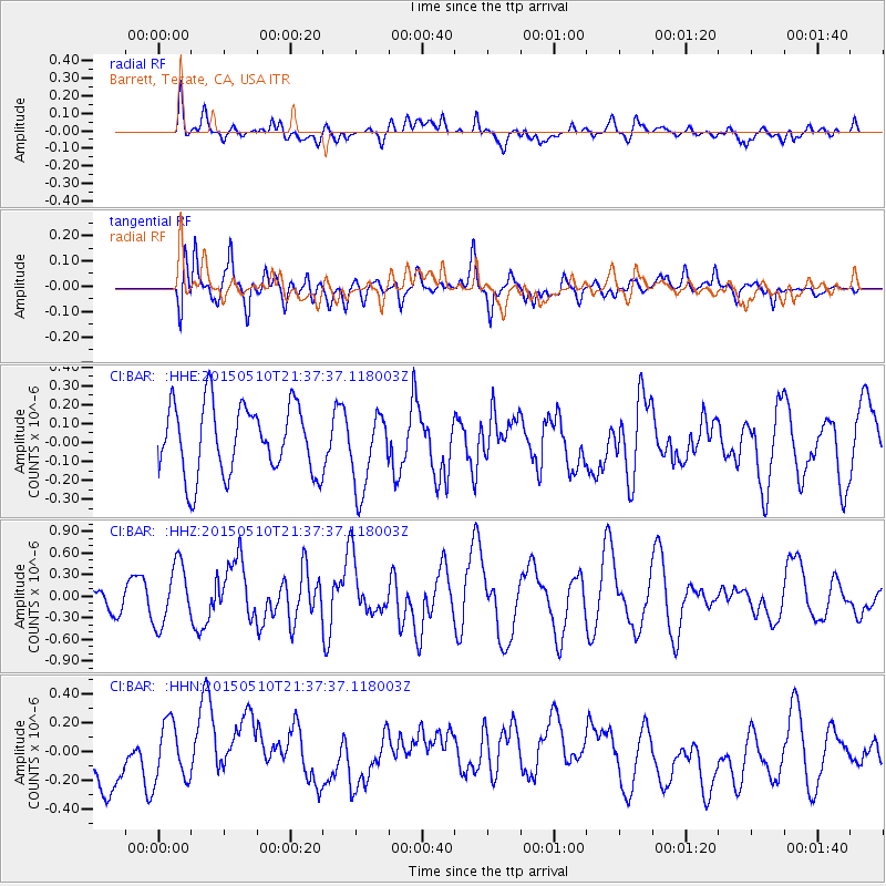
BAR Barrett, Tecate, CA, USA - Earthquake Result Viewer
*The percent match for this event was below the threshold and hence no stack was calculated.
| Earthquake location: |
Southeast Of Honshu, Japan |
| Earthquake latitude/longitude: |
31.2/142.4 |
| Earthquake time(UTC): |
2015/05/10 (130) 21:25:46 GMT |
| Earthquake Depth: |
18 km |
| Earthquake Magnitude: |
5.6 MB |
| Earthquake Catalog/Contributor: |
NEIC PDE/NEIC COMCAT |
|
| Network: |
CI Caltech Regional Seismic Network |
| Station: |
BAR Barrett, Tecate, CA, USA |
| Lat/Lon: |
32.68 N/116.67 W |
| Elevation: |
521 m |
|
| Distance: |
81.9 deg |
| Az: |
56.744 deg |
| Baz: |
301.869 deg |
| Ray Param: |
$rayparam |
*The percent match for this event was below the threshold and hence was not used in the summary stack. |
|
| Radial Match: |
52.75065 % |
| Radial Bump: |
400 |
| Transverse Match: |
61.2592 % |
| Transverse Bump: |
400 |
| SOD ConfigId: |
7422571 |
| Insert Time: |
2019-04-18 19:16:08.285 +0000 |
| GWidth: |
2.5 |
| Max Bumps: |
400 |
| Tol: |
0.001 |
|
Signal To Noise
| Channel | StoN | STA | LTA |
| CI:BAR: :HHZ:20150510T21:37:37.118003Z | 3.2468708 | 4.156337E-7 | 1.2801056E-7 |
| CI:BAR: :HHN:20150510T21:37:37.118003Z | 1.2385706 | 2.1125699E-7 | 1.7056516E-7 |
| CI:BAR: :HHE:20150510T21:37:37.118003Z | 1.1736116 | 2.1660105E-7 | 1.845594E-7 |
| Arrivals |
| Ps | |
| PpPs | |
| PsPs/PpSs | |


