You are here: Home > Network List > AZ - ANZA Regional Network Stations List
> Station SMER AZ.SMER > Earthquake Result Viewer
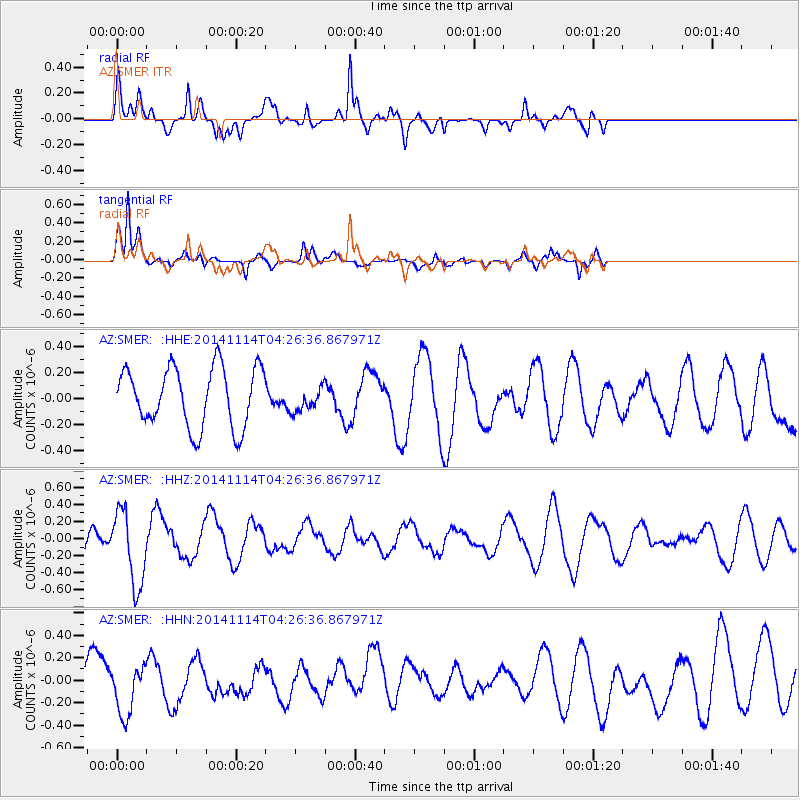
SMER AZ.SMER - Earthquake Result Viewer
*The percent match for this event was below the threshold and hence no stack was calculated.
| Earthquake location: |
Kuril Islands |
| Earthquake latitude/longitude: |
45.2/150.9 |
| Earthquake time(UTC): |
2014/11/14 (318) 04:16:07 GMT |
| Earthquake Depth: |
18 km |
| Earthquake Magnitude: |
5.7 MB |
| Earthquake Catalog/Contributor: |
NEIC PDE/NEIC COMCAT |
|
| Network: |
AZ ANZA Regional Network |
| Station: |
SMER AZ.SMER |
| Lat/Lon: |
33.46 N/117.17 W |
| Elevation: |
355 m |
|
| Distance: |
68.4 deg |
| Az: |
64.004 deg |
| Baz: |
310.54 deg |
| Ray Param: |
$rayparam |
*The percent match for this event was below the threshold and hence was not used in the summary stack. |
|
| Radial Match: |
56.18304 % |
| Radial Bump: |
400 |
| Transverse Match: |
76.447334 % |
| Transverse Bump: |
400 |
| SOD ConfigId: |
817051 |
| Insert Time: |
2014-11-28 04:24:50.719 +0000 |
| GWidth: |
2.5 |
| Max Bumps: |
400 |
| Tol: |
0.001 |
|
Signal To Noise
| Channel | StoN | STA | LTA |
| AZ:SMER: :HHZ:20141114T04:26:36.867971Z | 1.4178116 | 4.3523812E-7 | 3.0697882E-7 |
| AZ:SMER: :HHN:20141114T04:26:36.867971Z | 0.9903815 | 2.3786717E-7 | 2.4017734E-7 |
| AZ:SMER: :HHE:20141114T04:26:36.867971Z | 0.41628855 | 9.4722694E-8 | 2.2754095E-7 |
| Arrivals |
| Ps | |
| PpPs | |
| PsPs/PpSs | |


