You are here: Home > Network List > CN - Canadian National Seismograph Network Stations List
> Station INK INUVIK, NT > Earthquake Result Viewer
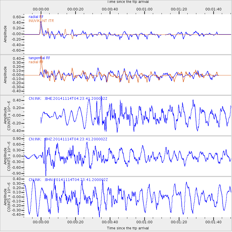
INK INUVIK, NT - Earthquake Result Viewer
*The percent match for this event was below the threshold and hence no stack was calculated.
| Earthquake location: |
Kuril Islands |
| Earthquake latitude/longitude: |
45.2/150.9 |
| Earthquake time(UTC): |
2014/11/14 (318) 04:16:07 GMT |
| Earthquake Depth: |
18 km |
| Earthquake Magnitude: |
5.7 MB |
| Earthquake Catalog/Contributor: |
NEIC PDE/NEIC COMCAT |
|
| Network: |
CN Canadian National Seismograph Network |
| Station: |
INK INUVIK, NT |
| Lat/Lon: |
68.31 N/133.53 W |
| Elevation: |
44 m |
|
| Distance: |
43.8 deg |
| Az: |
31.37 deg |
| Baz: |
278.245 deg |
| Ray Param: |
$rayparam |
*The percent match for this event was below the threshold and hence was not used in the summary stack. |
|
| Radial Match: |
62.373245 % |
| Radial Bump: |
400 |
| Transverse Match: |
57.352036 % |
| Transverse Bump: |
400 |
| SOD ConfigId: |
817051 |
| Insert Time: |
2014-11-28 04:28:18.814 +0000 |
| GWidth: |
2.5 |
| Max Bumps: |
400 |
| Tol: |
0.001 |
|
Signal To Noise
| Channel | StoN | STA | LTA |
| CN:INK: :BHZ:20141114T04:23:41.200002Z | 4.2645 | 3.605431E-7 | 8.454523E-8 |
| CN:INK: :BHN:20141114T04:23:41.200002Z | 0.9170288 | 1.5506818E-7 | 1.6909848E-7 |
| CN:INK: :BHE:20141114T04:23:41.200002Z | 1.6443244 | 1.7999842E-7 | 1.0946649E-7 |
| Arrivals |
| Ps | |
| PpPs | |
| PsPs/PpSs | |


