You are here: Home > Network List > KN - Kyrgyz Seismic Telemetry Network Stations List
> Station TKM2 - > Earthquake Result Viewer
TKM2 - - Earthquake Result Viewer
| Earthquake location: |
Southeast Of Honshu, Japan |
| Earthquake latitude/longitude: |
31.2/142.4 |
| Earthquake time(UTC): |
2015/05/10 (130) 21:25:46 GMT |
| Earthquake Depth: |
18 km |
| Earthquake Magnitude: |
5.6 MB |
| Earthquake Catalog/Contributor: |
NEIC PDE/NEIC COMCAT |
|
| Network: |
KN Kyrgyz Seismic Telemetry Network |
| Station: |
TKM2 - |
| Lat/Lon: |
42.92 N/75.60 E |
| Elevation: |
2020 m |
|
| Distance: |
53.3 deg |
| Az: |
302.595 deg |
| Baz: |
79.208 deg |
| Ray Param: |
0.06620534 |
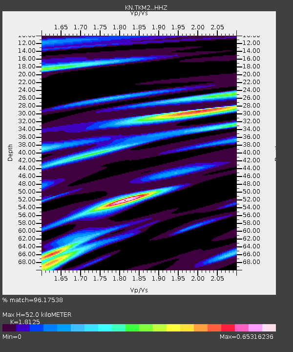
| Estimated Moho Depth: |
52.0 km |
| Estimated Crust Vp/Vs: |
1.81 |
| Assumed Crust Vp: |
6.306 km/s |
| Estimated Crust Vs: |
3.479 km/s |
| Estimated Crust Poisson's Ratio: |
0.28 |
|
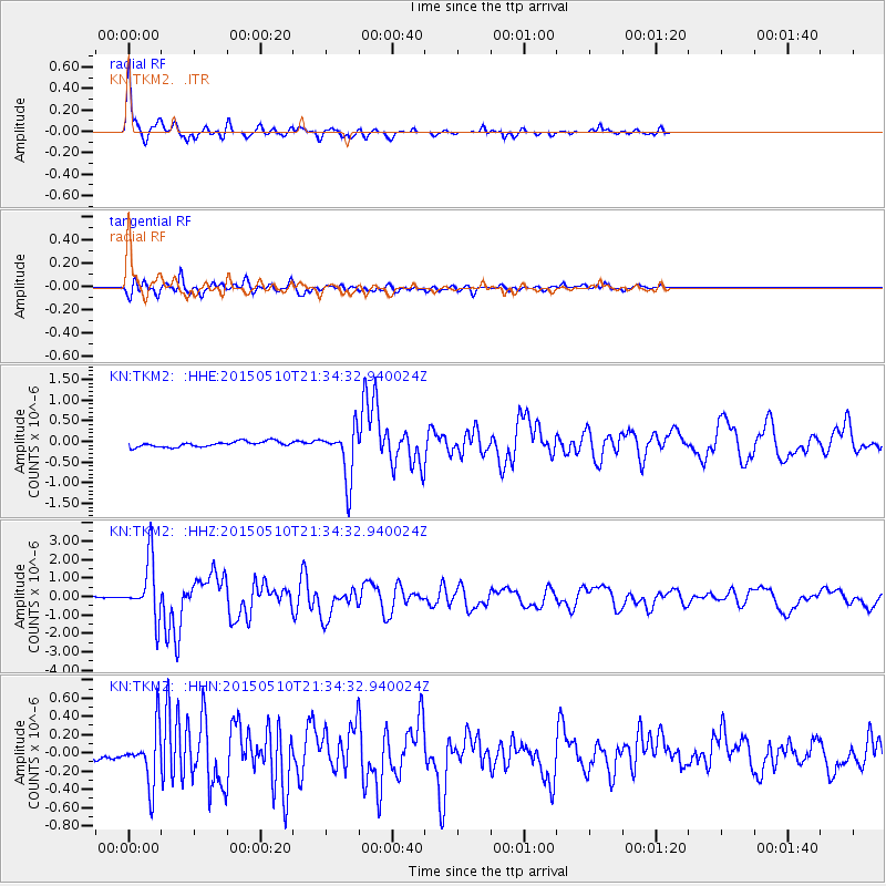
| Radial Match: |
96.17538 % |
| Radial Bump: |
254 |
| Transverse Match: |
87.87268 % |
| Transverse Bump: |
400 |
| SOD ConfigId: |
7422571 |
| Insert Time: |
2019-04-18 19:18:06.456 +0000 |
| GWidth: |
2.5 |
| Max Bumps: |
400 |
| Tol: |
0.001 |
|
Signal To Noise
| Channel | StoN | STA | LTA |
| KN:TKM2: :HHZ:20150510T21:34:32.940024Z | 29.08074 | 1.5232591E-6 | 5.2380344E-8 |
| KN:TKM2: :HHN:20150510T21:34:32.940024Z | 6.82404 | 2.98933E-7 | 4.380587E-8 |
| KN:TKM2: :HHE:20150510T21:34:32.940024Z | 9.411649 | 6.2642187E-7 | 6.6558144E-8 |
| Arrivals |
| Ps | 7.1 SECOND |
| PpPs | 22 SECOND |
| PsPs/PpSs | 29 SECOND |


