You are here: Home > Network List > NE - New England Seismic Network Stations List
> Station EMMW Machias, ME, USA > Earthquake Result Viewer
EMMW Machias, ME, USA - Earthquake Result Viewer
*The percent match for this event was below the threshold and hence no stack was calculated.
| Earthquake location: |
Kuril Islands |
| Earthquake latitude/longitude: |
45.2/150.9 |
| Earthquake time(UTC): |
2014/11/14 (318) 04:16:07 GMT |
| Earthquake Depth: |
18 km |
| Earthquake Magnitude: |
5.7 MB |
| Earthquake Catalog/Contributor: |
NEIC PDE/NEIC COMCAT |
|
| Network: |
NE New England Seismic Network |
| Station: |
EMMW Machias, ME, USA |
| Lat/Lon: |
44.71 N/67.46 W |
| Elevation: |
35 m |
|
| Distance: |
84.2 deg |
| Az: |
26.429 deg |
| Baz: |
333.82 deg |
| Ray Param: |
$rayparam |
*The percent match for this event was below the threshold and hence was not used in the summary stack. |
|
| Radial Match: |
53.170914 % |
| Radial Bump: |
374 |
| Transverse Match: |
72.03405 % |
| Transverse Bump: |
400 |
| SOD ConfigId: |
817051 |
| Insert Time: |
2014-11-28 04:39:08.851 +0000 |
| GWidth: |
2.5 |
| Max Bumps: |
400 |
| Tol: |
0.001 |
|
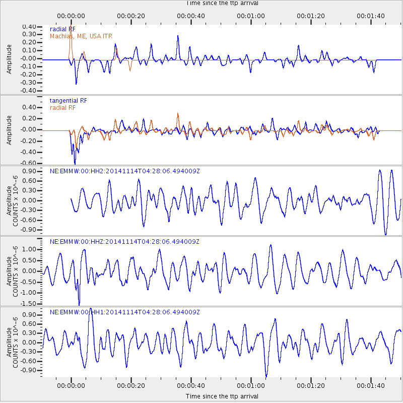
Signal To Noise
| Channel | StoN | STA | LTA |
| NE:EMMW:00:HHZ:20141114T04:28:06.494009Z | 2.1782882 | 7.2207547E-7 | 3.314876E-7 |
| NE:EMMW:00:HH1:20141114T04:28:06.494009Z | 1.6332625 | 3.6280667E-7 | 2.2213617E-7 |
| NE:EMMW:00:HH2:20141114T04:28:06.494009Z | 1.0003324 | 2.9614927E-7 | 2.9605087E-7 |
| Arrivals |
| Ps | |
| PpPs | |
| PsPs/PpSs | |


