You are here: Home > Network List > TA - USArray Transportable Network (new EarthScope stations) Stations List
> Station G59A Clarenceville, QC, USA > Earthquake Result Viewer
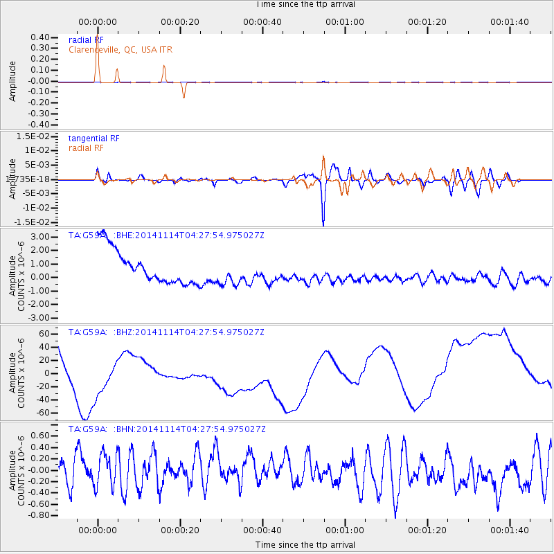
G59A Clarenceville, QC, USA - Earthquake Result Viewer
*The percent match for this event was below the threshold and hence no stack was calculated.
| Earthquake location: |
Kuril Islands |
| Earthquake latitude/longitude: |
45.2/150.9 |
| Earthquake time(UTC): |
2014/11/14 (318) 04:16:07 GMT |
| Earthquake Depth: |
18 km |
| Earthquake Magnitude: |
5.7 MB |
| Earthquake Catalog/Contributor: |
NEIC PDE/NEIC COMCAT |
|
| Network: |
TA USArray Transportable Network (new EarthScope stations) |
| Station: |
G59A Clarenceville, QC, USA |
| Lat/Lon: |
45.08 N/73.18 W |
| Elevation: |
36 m |
|
| Distance: |
82.0 deg |
| Az: |
29.871 deg |
| Baz: |
330.206 deg |
| Ray Param: |
$rayparam |
*The percent match for this event was below the threshold and hence was not used in the summary stack. |
|
| Radial Match: |
50.749454 % |
| Radial Bump: |
400 |
| Transverse Match: |
53.2332 % |
| Transverse Bump: |
400 |
| SOD ConfigId: |
817051 |
| Insert Time: |
2014-11-28 04:44:33.804 +0000 |
| GWidth: |
2.5 |
| Max Bumps: |
400 |
| Tol: |
0.001 |
|
Signal To Noise
| Channel | StoN | STA | LTA |
| TA:G59A: :BHZ:20141114T04:27:54.975027Z | 1.3643887 | 5.9859904E-5 | 4.3873057E-5 |
| TA:G59A: :BHN:20141114T04:27:54.975027Z | 1.2926897 | 3.345375E-7 | 2.5879183E-7 |
| TA:G59A: :BHE:20141114T04:27:54.975027Z | 0.85232884 | 1.0733586E-6 | 1.2593246E-6 |
| Arrivals |
| Ps | |
| PpPs | |
| PsPs/PpSs | |


