You are here: Home > Network List > TA - USArray Transportable Network (new EarthScope stations) Stations List
> Station N23A Red Feather Lakes, CO, USA > Earthquake Result Viewer
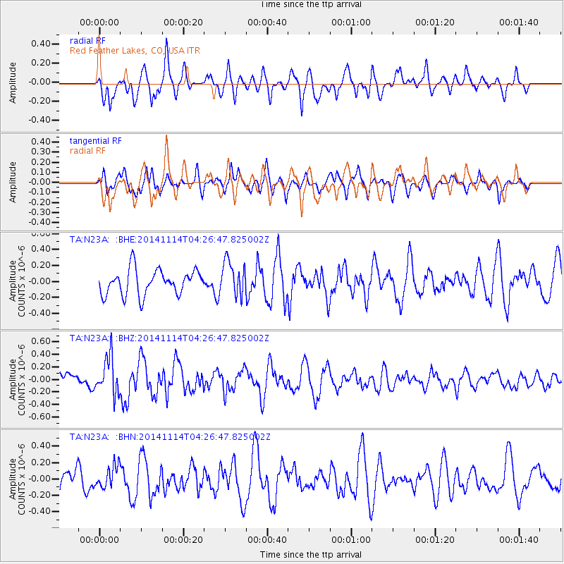
N23A Red Feather Lakes, CO, USA - Earthquake Result Viewer
*The percent match for this event was below the threshold and hence no stack was calculated.
| Earthquake location: |
Kuril Islands |
| Earthquake latitude/longitude: |
45.2/150.9 |
| Earthquake time(UTC): |
2014/11/14 (318) 04:16:07 GMT |
| Earthquake Depth: |
18 km |
| Earthquake Magnitude: |
5.7 MB |
| Earthquake Catalog/Contributor: |
NEIC PDE/NEIC COMCAT |
|
| Network: |
TA USArray Transportable Network (new EarthScope stations) |
| Station: |
N23A Red Feather Lakes, CO, USA |
| Lat/Lon: |
40.89 N/105.94 W |
| Elevation: |
2458 m |
|
| Distance: |
70.1 deg |
| Az: |
51.717 deg |
| Baz: |
312.956 deg |
| Ray Param: |
$rayparam |
*The percent match for this event was below the threshold and hence was not used in the summary stack. |
|
| Radial Match: |
55.386868 % |
| Radial Bump: |
400 |
| Transverse Match: |
60.572094 % |
| Transverse Bump: |
400 |
| SOD ConfigId: |
817051 |
| Insert Time: |
2014-11-28 04:45:55.946 +0000 |
| GWidth: |
2.5 |
| Max Bumps: |
400 |
| Tol: |
0.001 |
|
Signal To Noise
| Channel | StoN | STA | LTA |
| TA:N23A: :BHZ:20141114T04:26:47.825002Z | 1.6898487 | 3.00136E-7 | 1.7761118E-7 |
| TA:N23A: :BHN:20141114T04:26:47.825002Z | 0.97077376 | 1.3470098E-7 | 1.387563E-7 |
| TA:N23A: :BHE:20141114T04:26:47.825002Z | 1.3936658 | 2.1893919E-7 | 1.570959E-7 |
| Arrivals |
| Ps | |
| PpPs | |
| PsPs/PpSs | |


