You are here: Home > Network List > TA - USArray Transportable Network (new EarthScope stations) Stations List
> Station S56A Natural Bridge, VA, USA > Earthquake Result Viewer
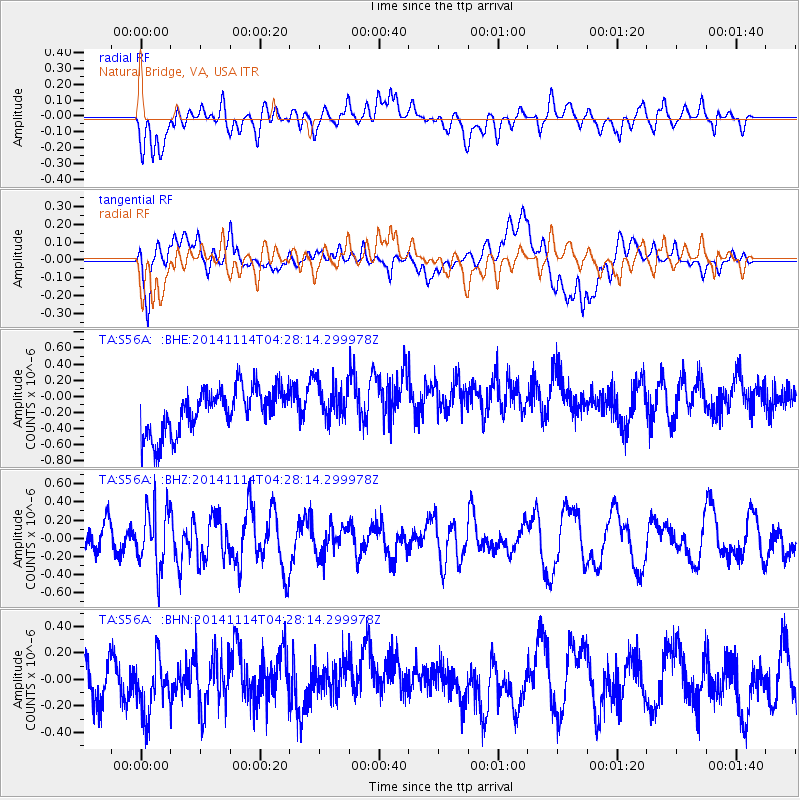
S56A Natural Bridge, VA, USA - Earthquake Result Viewer
*The percent match for this event was below the threshold and hence no stack was calculated.
| Earthquake location: |
Kuril Islands |
| Earthquake latitude/longitude: |
45.2/150.9 |
| Earthquake time(UTC): |
2014/11/14 (318) 04:16:07 GMT |
| Earthquake Depth: |
18 km |
| Earthquake Magnitude: |
5.7 MB |
| Earthquake Catalog/Contributor: |
NEIC PDE/NEIC COMCAT |
|
| Network: |
TA USArray Transportable Network (new EarthScope stations) |
| Station: |
S56A Natural Bridge, VA, USA |
| Lat/Lon: |
37.68 N/79.57 W |
| Elevation: |
449 m |
|
| Distance: |
85.8 deg |
| Az: |
37.873 deg |
| Baz: |
326.846 deg |
| Ray Param: |
$rayparam |
*The percent match for this event was below the threshold and hence was not used in the summary stack. |
|
| Radial Match: |
42.12038 % |
| Radial Bump: |
400 |
| Transverse Match: |
48.111725 % |
| Transverse Bump: |
400 |
| SOD ConfigId: |
817051 |
| Insert Time: |
2014-11-28 04:46:56.488 +0000 |
| GWidth: |
2.5 |
| Max Bumps: |
400 |
| Tol: |
0.001 |
|
Signal To Noise
| Channel | StoN | STA | LTA |
| TA:S56A: :BHZ:20141114T04:28:14.299978Z | 1.922589 | 3.2955438E-7 | 1.7141178E-7 |
| TA:S56A: :BHN:20141114T04:28:14.299978Z | 1.1169124 | 2.0646236E-7 | 1.8485098E-7 |
| TA:S56A: :BHE:20141114T04:28:14.299978Z | 0.9302597 | 2.537362E-7 | 2.7275846E-7 |
| Arrivals |
| Ps | |
| PpPs | |
| PsPs/PpSs | |


