You are here: Home > Network List > TA - USArray Transportable Network (new EarthScope stations) Stations List
> Station V57A Coltrane Farms, NC, USA > Earthquake Result Viewer
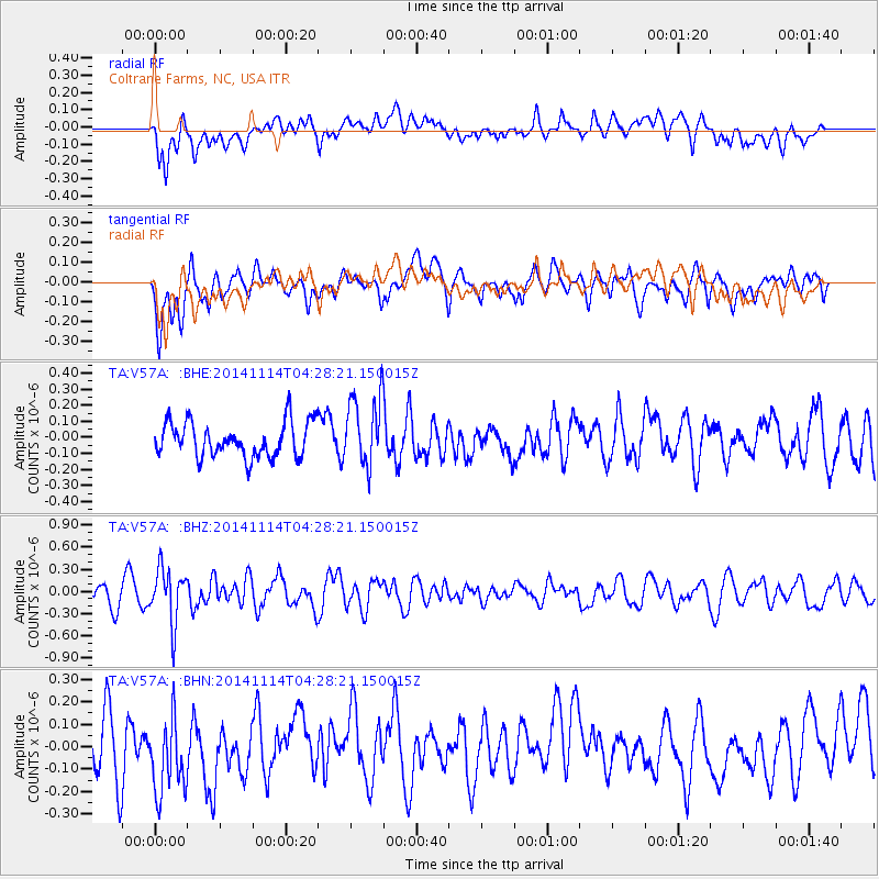
V57A Coltrane Farms, NC, USA - Earthquake Result Viewer
*The percent match for this event was below the threshold and hence no stack was calculated.
| Earthquake location: |
Kuril Islands |
| Earthquake latitude/longitude: |
45.2/150.9 |
| Earthquake time(UTC): |
2014/11/14 (318) 04:16:07 GMT |
| Earthquake Depth: |
18 km |
| Earthquake Magnitude: |
5.7 MB |
| Earthquake Catalog/Contributor: |
NEIC PDE/NEIC COMCAT |
|
| Network: |
TA USArray Transportable Network (new EarthScope stations) |
| Station: |
V57A Coltrane Farms, NC, USA |
| Lat/Lon: |
35.89 N/79.78 W |
| Elevation: |
223 m |
|
| Distance: |
87.2 deg |
| Az: |
38.993 deg |
| Baz: |
326.79 deg |
| Ray Param: |
$rayparam |
*The percent match for this event was below the threshold and hence was not used in the summary stack. |
|
| Radial Match: |
53.05353 % |
| Radial Bump: |
400 |
| Transverse Match: |
64.25275 % |
| Transverse Bump: |
400 |
| SOD ConfigId: |
817051 |
| Insert Time: |
2014-11-28 04:47:41.935 +0000 |
| GWidth: |
2.5 |
| Max Bumps: |
400 |
| Tol: |
0.001 |
|
Signal To Noise
| Channel | StoN | STA | LTA |
| TA:V57A: :BHZ:20141114T04:28:21.150015Z | 2.6221845 | 3.6590063E-7 | 1.3954039E-7 |
| TA:V57A: :BHN:20141114T04:28:21.150015Z | 1.4819672 | 1.7669383E-7 | 1.1922924E-7 |
| TA:V57A: :BHE:20141114T04:28:21.150015Z | 2.0382338 | 2.1751137E-7 | 1.0671562E-7 |
| Arrivals |
| Ps | |
| PpPs | |
| PsPs/PpSs | |


