You are here: Home > Network List > TA - USArray Transportable Network (new EarthScope stations) Stations List
> Station J01E Myrtle Point, OR, USA > Earthquake Result Viewer
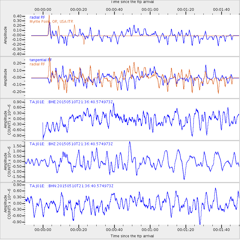
J01E Myrtle Point, OR, USA - Earthquake Result Viewer
*The percent match for this event was below the threshold and hence no stack was calculated.
| Earthquake location: |
Southeast Of Honshu, Japan |
| Earthquake latitude/longitude: |
31.2/142.4 |
| Earthquake time(UTC): |
2015/05/10 (130) 21:25:46 GMT |
| Earthquake Depth: |
18 km |
| Earthquake Magnitude: |
5.6 MB |
| Earthquake Catalog/Contributor: |
NEIC PDE/NEIC COMCAT |
|
| Network: |
TA USArray Transportable Network (new EarthScope stations) |
| Station: |
J01E Myrtle Point, OR, USA |
| Lat/Lon: |
43.16 N/123.93 W |
| Elevation: |
128 m |
|
| Distance: |
71.9 deg |
| Az: |
50.212 deg |
| Baz: |
295.916 deg |
| Ray Param: |
$rayparam |
*The percent match for this event was below the threshold and hence was not used in the summary stack. |
|
| Radial Match: |
41.619072 % |
| Radial Bump: |
400 |
| Transverse Match: |
45.867428 % |
| Transverse Bump: |
400 |
| SOD ConfigId: |
7422571 |
| Insert Time: |
2019-04-18 19:20:14.230 +0000 |
| GWidth: |
2.5 |
| Max Bumps: |
400 |
| Tol: |
0.001 |
|
Signal To Noise
| Channel | StoN | STA | LTA |
| TA:J01E: :BHZ:20150510T21:36:40.574973Z | 1.5999309 | 3.174116E-7 | 1.9839081E-7 |
| TA:J01E: :BHN:20150510T21:36:40.574973Z | 1.8279126 | 6.0495336E-7 | 3.309531E-7 |
| TA:J01E: :BHE:20150510T21:36:40.574973Z | 1.4016855 | 4.462285E-7 | 3.183514E-7 |
| Arrivals |
| Ps | |
| PpPs | |
| PsPs/PpSs | |


