You are here: Home > Network List > TJ - Tajikistan National Seismic Network Stations List
> Station GARM Garm, Tajikistan > Earthquake Result Viewer
GARM Garm, Tajikistan - Earthquake Result Viewer
| Earthquake location: |
Southeast Of Honshu, Japan |
| Earthquake latitude/longitude: |
31.2/142.4 |
| Earthquake time(UTC): |
2015/05/10 (130) 21:25:46 GMT |
| Earthquake Depth: |
18 km |
| Earthquake Magnitude: |
5.6 MB |
| Earthquake Catalog/Contributor: |
NEIC PDE/NEIC COMCAT |
|
| Network: |
TJ Tajikistan National Seismic Network |
| Station: |
GARM Garm, Tajikistan |
| Lat/Lon: |
39.00 N/70.32 E |
| Elevation: |
1305 m |
|
| Distance: |
58.1 deg |
| Az: |
299.118 deg |
| Baz: |
73.792 deg |
| Ray Param: |
0.063075595 |
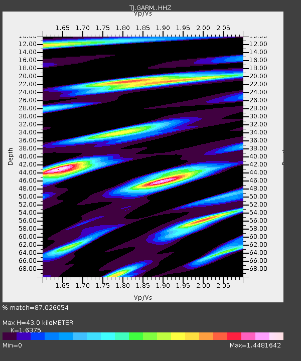
| Estimated Moho Depth: |
43.0 km |
| Estimated Crust Vp/Vs: |
1.64 |
| Assumed Crust Vp: |
6.306 km/s |
| Estimated Crust Vs: |
3.851 km/s |
| Estimated Crust Poisson's Ratio: |
0.20 |
|
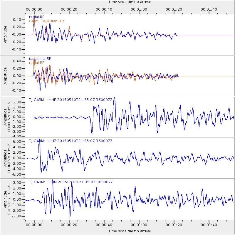
| Radial Match: |
87.026054 % |
| Radial Bump: |
400 |
| Transverse Match: |
84.8887 % |
| Transverse Bump: |
400 |
| SOD ConfigId: |
7422571 |
| Insert Time: |
2019-04-18 19:20:32.354 +0000 |
| GWidth: |
2.5 |
| Max Bumps: |
400 |
| Tol: |
0.001 |
|
Signal To Noise
| Channel | StoN | STA | LTA |
| TJ:GARM: :HHZ:20150510T21:35:07.360007Z | 16.317566 | 2.9031914E-6 | 1.7791817E-7 |
| TJ:GARM: :HHN:20150510T21:35:07.360007Z | 3.7272148 | 3.01891E-7 | 8.09964E-8 |
| TJ:GARM: :HHE:20150510T21:35:07.360007Z | 14.639666 | 1.437434E-6 | 9.818763E-8 |
| Arrivals |
| Ps | 4.6 SECOND |
| PpPs | 17 SECOND |
| PsPs/PpSs | 22 SECOND |


