You are here: Home > Network List > TJ - Tajikistan National Seismic Network Stations List
> Station SHAA Shaartuz, Tajikistan > Earthquake Result Viewer
SHAA Shaartuz, Tajikistan - Earthquake Result Viewer

| Earthquake location: |
Southeast Of Honshu, Japan |
| Earthquake latitude/longitude: |
31.2/142.4 |
| Earthquake time(UTC): |
2015/05/10 (130) 21:25:46 GMT |
| Earthquake Depth: |
18 km |
| Earthquake Magnitude: |
5.6 MB |
| Earthquake Catalog/Contributor: |
NEIC PDE/NEIC COMCAT |
|
| Network: |
TJ Tajikistan National Seismic Network |
| Station: |
SHAA Shaartuz, Tajikistan |
| Lat/Lon: |
37.56 N/68.12 E |
| Elevation: |
868 m |
|
| Distance: |
60.1 deg |
| Az: |
298.112 deg |
| Baz: |
71.922 deg |
| Ray Param: |
0.061718874 |
| Estimated Moho Depth: |
48.5 km |
| Estimated Crust Vp/Vs: |
1.61 |
| Assumed Crust Vp: |
6.213 km/s |
| Estimated Crust Vs: |
3.853 km/s |
| Estimated Crust Poisson's Ratio: |
0.19 |
|
| Radial Match: |
84.84976 % |
| Radial Bump: |
400 |
| Transverse Match: |
74.52467 % |
| Transverse Bump: |
400 |
| SOD ConfigId: |
7422571 |
| Insert Time: |
2019-04-18 19:20:34.043 +0000 |
| GWidth: |
2.5 |
| Max Bumps: |
400 |
| Tol: |
0.001 |
|
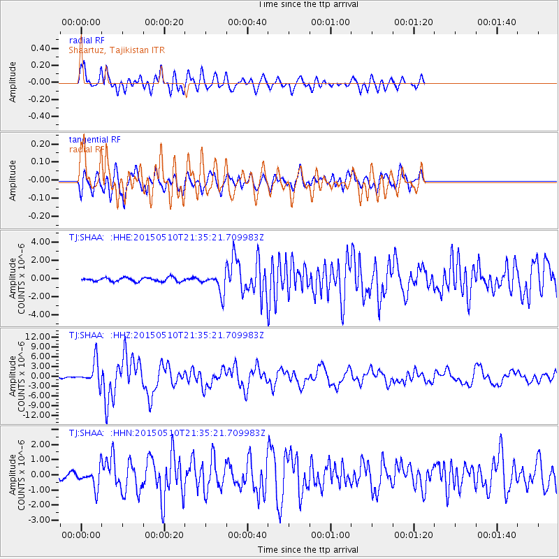
Signal To Noise
| Channel | StoN | STA | LTA |
| TJ:SHAA: :HHZ:20150510T21:35:21.709983Z | 16.802246 | 3.6967626E-6 | 2.2001599E-7 |
| TJ:SHAA: :HHN:20150510T21:35:21.709983Z | 4.9389596 | 7.153176E-7 | 1.4483163E-7 |
| TJ:SHAA: :HHE:20150510T21:35:21.709983Z | 5.67259 | 1.1891207E-6 | 2.0962571E-7 |
| Arrivals |
| Ps | 5.0 SECOND |
| PpPs | 19 SECOND |
| PsPs/PpSs | 24 SECOND |


