You are here: Home > Network List > US - United States National Seismic Network Stations List
> Station EGMT Eagleton, Montana, USA > Earthquake Result Viewer
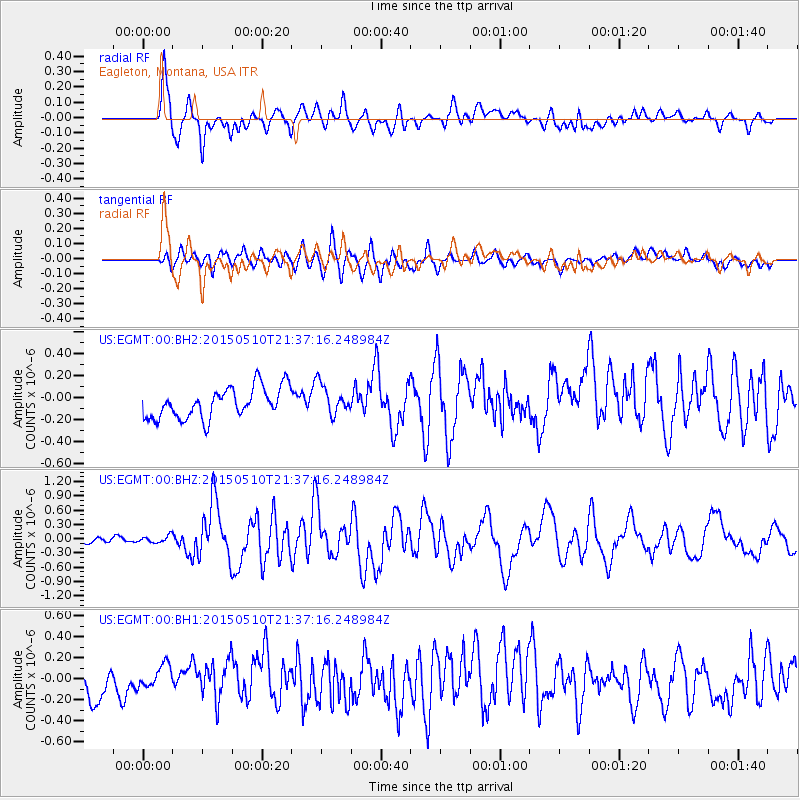
EGMT Eagleton, Montana, USA - Earthquake Result Viewer
*The percent match for this event was below the threshold and hence no stack was calculated.
| Earthquake location: |
Southeast Of Honshu, Japan |
| Earthquake latitude/longitude: |
31.2/142.4 |
| Earthquake time(UTC): |
2015/05/10 (130) 21:25:46 GMT |
| Earthquake Depth: |
18 km |
| Earthquake Magnitude: |
5.6 MB |
| Earthquake Catalog/Contributor: |
NEIC PDE/NEIC COMCAT |
|
| Network: |
US United States National Seismic Network |
| Station: |
EGMT Eagleton, Montana, USA |
| Lat/Lon: |
48.02 N/109.75 W |
| Elevation: |
1055 m |
|
| Distance: |
78.1 deg |
| Az: |
40.763 deg |
| Baz: |
303.587 deg |
| Ray Param: |
$rayparam |
*The percent match for this event was below the threshold and hence was not used in the summary stack. |
|
| Radial Match: |
81.95452 % |
| Radial Bump: |
400 |
| Transverse Match: |
70.0955 % |
| Transverse Bump: |
400 |
| SOD ConfigId: |
7422571 |
| Insert Time: |
2019-04-18 19:20:55.856 +0000 |
| GWidth: |
2.5 |
| Max Bumps: |
400 |
| Tol: |
0.001 |
|
Signal To Noise
| Channel | StoN | STA | LTA |
| US:EGMT:00:BHZ:20150510T21:37:16.248984Z | 1.1432289 | 7.379533E-8 | 6.4549916E-8 |
| US:EGMT:00:BH1:20150510T21:37:16.248984Z | 0.70243675 | 1.1616152E-7 | 1.6536937E-7 |
| US:EGMT:00:BH2:20150510T21:37:16.248984Z | 1.2176064 | 1.603308E-7 | 1.3167703E-7 |
| Arrivals |
| Ps | |
| PpPs | |
| PsPs/PpSs | |


